Cueva del Agua, Garafia facts for kids
Quick facts for kids
Cueva del Agua
|
|
|---|---|
|
Municipality district
|
|

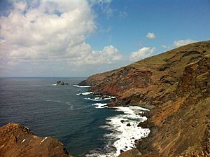
La Palma, N-W: cliffs of Garafía's municipality and the Callejoncito beach
|
|
|
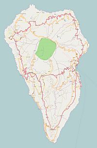
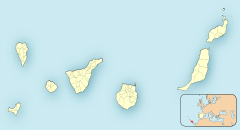
Location of Cueva del Agua on La Palma island
|
|
| Country | |
| Autonomous community | |
| Province | |
| Island | |
| Municipality | Garafía |
Cueva del Agua is a small village in Garafía, a part of La Palma island. This island is one of the Canary Islands, which are off the coast of Morocco. It is located in the province of Santa Cruz de Tenerife, Spain.
Contents
Exploring Cueva del Agua
Cueva del Agua is a village on the island of La Palma. It is about 1.5 kilometers east of the LP-114 road. This road connects Santo Domingo to Las Tricias. The village is nestled between El Castillo to the south and Santo Domingo to the north. The northwest coast of the island is not far away.
The area around Cueva del Agua is very mountainous. It has winding roads and deep, narrow valleys. Two important ravines, or barrancos, are nearby. These are the Atajo river ravine to the south and the Fernando Oporto ravine to the north.
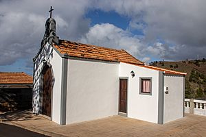
In the center of the village, you will find the Chapel of Our Lady of Sorrows. There is also an old school building.
What Does the Name Mean?
The name of the village, Cueva del Agua, means "Cave of Water" in English. This name comes from a real cave nearby. Inside this cave, there is a natural spring where water flows out. This special cave is also known as the "Spring Cave" (cueva de la Fuente).
Village Population
The number of people living in Cueva del Agua has gone down a lot since the 1950s. Today, about 120 people call this village home.
History and Old Discoveries
The Chapel of Our Lady of Sorrows
This chapel is a small, simple building. It has one main room and a roof covered with curved ceramic tiles. The front of the chapel has a triangular top. On top of that, there's a wall with a bell and a cross. The entrance door is made from Canarian pine wood and has a rounded arch shape.
About Our Lady of Sorrows
The statue inside the chapel is called the Lady of Sorrows. Her eyes are made of crystal. This image shows the Virgin Mary feeling great sadness. She is shown alone after her Son, Jesus, was crucified. This type of image became very important in Spain from the 1500s. It represents Mary's deep pain and sorrow.
Ancient Rock Engravings at El Callejoncito
This area is famous for its ancient rock engravings, also called petroglyphs. They are found on a rocky spot above the Atajo ravine. There are six panels of these engravings still in their original places. The designs are geometric, meaning they use shapes like spirals, zigzags, and wavy lines.
These patterns were made by punching marks into the stone. The marks vary in width and length. Sadly, these old artworks are slowly wearing away due to weather. They were first shared with the public in 1970 by Dr. Mauro Hernández Perez. Later, they were studied more closely in 1988.
Near these engravings, there was once an old village from prehistoric times. People lived in caves along the Atajo ravine. These caves were good places to live because they were big, bright, and offered protection from bad weather. People used these caves for a long time. Some caves have even been raided, meaning things were taken from them.
When archaeologists explored this site, they found pieces of pottery jars. They also found stone tools like chips and cores made from basalt rock. Bones from sheep and goats were discovered, along with many limpet shells.
Many rock engravings are found in Cueva del Agua and the wider Garafía area. Some have been lost, especially when roads were built. However, many still remain. For example, near Cueva del Agua's windmill, at a place called The Calvary, there are 17 engraved panels. Most of these designs are circles and spirals. This spot is well-known and easy to visit. Another engraving was found in 1997 hidden in a wall.
El Callejoncito Beach
At the end of the Atajo river, you'll find a small beach called El Callejoncito. It has black volcanic sand and is surrounded by tall cliffs. The beach stretches for about 100 meters. The black sand is brought down by the tides.
While it's a quiet beach in winter, it can have strong currents. So, if you plan to swim, be very careful! You can reach the beach from the LP-114 road. There's a paved lane that leads to a parking area. From there, it's about a 1-kilometer walk to the beach.
The Spring Cave
This cave, known as Cueva de la Fuente, is on the north side of the ravine that leads to Callejoncito. Its entrance is under a natural rock arch. It's a large cave that has been used to shelter goats, so it's fenced off. You can see some cement and brickwork related to the spring inside. This cave was formed by volcanic activity. It runs parallel to the coastline, not towards it.
Village Celebrations
The village of Cueva del Agua celebrates its main feast in September. This celebration honors Our Lady of Sorrows, who is the village's patron saint. During this time, there are fun street parties and various cultural events for everyone to enjoy.
See also
 In Spanish: Cueva del Agua (Garafía) para niños
 | Selma Burke |
 | Pauline Powell Burns |
 | Frederick J. Brown |
 | Robert Blackburn |


