Cuivre River State Park facts for kids
Quick facts for kids Cuivre River State Park |
|
|---|---|

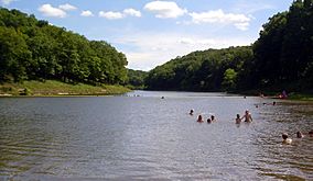
Swimming area in Lincoln Lake
|
|
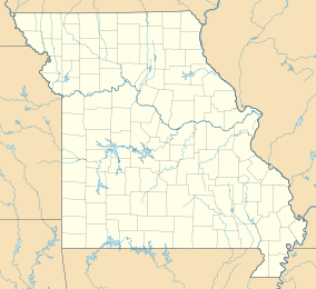
| Location | Lincoln, Missouri, United States |
| Area | 6,426.94 acres (26.0089 km2) |
| Elevation | 548 ft (167 m) |
| Established | 1946 |
| Governing body | Missouri Department of Natural Resources |
| Website | Cuivre River State Park |
|
Camp Sherwood Forest Historic District
|
|
| Nearest city | Elsberry, Missouri |
| Area | 132 acres (53 ha) |
| Built | 1936 |
| Built by | CCC |
| Architectural style | Rustic |
| MPS | ECW Architecture in Missouri State Parks 1933-1942 TR |
| NRHP reference No. | 85000512 |
| Added to NRHP | March 4, 1985 |
|
Cuivre River State Park Administrative Area Historic District
|
|
| Nearest city | Troy, Missouri |
| Area | 620 acres (250 ha) |
| Built | 1934 |
| Built by | CCC; WPA |
| Architectural style | Rustic |
| MPS | ECW Architecture in Missouri State Parks 1933-1942 TR |
| NRHP reference No. | 85000514 |
| Added to NRHP | March 4, 1985 |
Cuivre River State Park is a huge outdoor area in Missouri, United States. It covers over 6,400 acres! That's like more than 4,800 football fields. This park is northeast of the city of Troy. It is known for its beautiful and wild landscapes.
You can find everything from grassy plains and open woodlands to tall limestone cliffs. These cliffs look out over forested hills. The park has many trails for hiking and other activities. You can also go swimming and camping here. The Missouri Department of Natural Resources manages this amazing park.
Contents
Discovering Cuivre River State Park
Cuivre River State Park is a special place for nature lovers. It includes three important natural areas. The Lincoln Hills Natural Area is a large part of the park, covering 1,872 acres. There are also two "wild areas" where nature is left mostly untouched. These are the Big Sugar Creek Wild Area (1,675 acres) and the Northwoods Wild Area (1,082 acres). These areas protect different kinds of plants and animals.
A Look Back: How the Park Started
Cuivre River State Park began in the 1930s. At that time, the United States government created special areas for recreation. Workers from two important groups helped build the park. These groups were the Civilian Conservation Corps (CCC) and the Works Progress Administration (WPA).
These workers built many things that are still used today. They constructed roads, bridges, and places for groups to camp. They also built picnic shelters. Missouri took over the park in 1946.
Historic Buildings and Areas
Two parts of the park are very important historically. They are called "historic districts." These districts were added to the National Register of Historic Places in 1985. This means they are protected because of their history.
- Camp Sherwood Forest: This area has 52 buildings and structures. The Civilian Conservation Corps built them between 1934 and 1936. Some of these buildings include an Amphitheater, a Dining Lodge, and a Recreation Hall. There are also cabins and kitchen units in areas like Ancaster Village and Nottingham Village. These buildings show how people lived and worked in the park long ago.
- Cuivre River State Park Administrative Area: This district includes six buildings and structures. The Civilian Conservation Corps and the Works Projects Administration built them from 1934 to 1941. Examples include a bridge, a shelter, a wellhouse, and the park office. These buildings were important for managing the park.
Fun Things to Do at the Park
Cuivre River State Park offers many activities for visitors. You can stay overnight at one of the two campgrounds. If you like a more rugged adventure, you can try backpack camping. Fishing is popular on Sugar Creek. You can also go swimming or canoeing on Lake Lincoln, which is 55 acres big.
The park has a huge network of trails. These trails are perfect for hiking, cycling, and even horseback riding. There are trails for all skill levels, from short walks to long adventures.
Park Trails for Exploration
Here are some of the trails you can explore at Cuivre River State Park:
| Trail | Length |
|---|---|
| Big Sugar Creek Trail | 3.75 miles (6.04 km) |
| Blackhawk Point Trail | 5.75 miles (9.25 km) |
| Blazing Star Trail | 2 miles (3.2 km) |
| Cuivre River Trail | 11.25 miles (18.11 km) |
| Frenchman's Bluff Trail | 1.5 miles (2.4 km) |
| Hamilton Hollow Trail | .9 miles (1.4 km) |
| Lakeside Trail | 3.5 miles (5.6 km) |
| Lone Spring Trail | 5.2 miles (8.4 km) |
| Mossy Hill Trail | .8 miles (1.3 km) |
| Old Schoolhouse Trail | 3.85 miles (6.20 km) |
| Prairie Trail | .3 miles (0.48 km) |
| Turkey Hollow Trail | .8 miles (1.3 km) |
 | Jackie Robinson |
 | Jack Johnson |
 | Althea Gibson |
 | Arthur Ashe |
 | Muhammad Ali |


