Cullerin facts for kids
Quick facts for kids CullerinNew South Wales |
|||||||||||||||
|---|---|---|---|---|---|---|---|---|---|---|---|---|---|---|---|

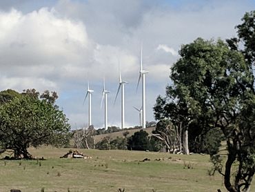
Cullerin Range Wind Farm from Cullerin
|
|||||||||||||||
| Population | 38 (2016 census) | ||||||||||||||
| Postcode(s) | 2581 | ||||||||||||||
| Elevation | 649 m (2,129 ft) | ||||||||||||||
| Location | |||||||||||||||
| LGA(s) | Upper Lachlan Shire | ||||||||||||||
| County | King | ||||||||||||||
| Parish | Cullarin | ||||||||||||||
| State electorate(s) | Goulburn | ||||||||||||||
| Federal Division(s) | Hume | ||||||||||||||
|
|||||||||||||||
Cullerin is a very small town, also called a township. It is located in the Southern Tablelands region of New South Wales, Australia. This area is known for its rolling hills and open spaces.
Cullerin sits right on the Old Hume Highway. This is an important road that connects different parts of Australia. It is also on the Main South railway line. This railway helps transport goods and people.
The town is part of the Upper Lachlan Shire. A railway station in Cullerin opened in 1880. It served the community for many years before closing in 1973. In 2016, only 38 people lived in Cullerin.
Getting Around Cullerin
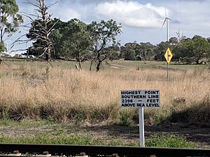
Cullerin is located at a special spot on the Main Southern Rail line. It is at the highest point of a 15-kilometer (about 9 miles) uphill section. This means trains have to climb quite a bit to reach Cullerin.
The town is also just a few kilometers west of the Great Dividing Range. This is a huge mountain range that runs along the eastern side of Australia. It acts like a big natural wall.
Because of this range, rivers on the west side of Cullerin, like the Lachlan River, flow inland. They head towards the center of Australia. Rivers on the east side, like the Wollondilly River, flow towards the Pacific Ocean. This shows how the Great Dividing Range affects where water goes!


