Cumbal facts for kids
Quick facts for kids
Cumbal
|
||
|---|---|---|
|
Municipality and town
|
||

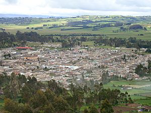
View of Cumbal
|
||
|
||

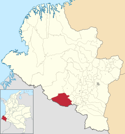
Location of the municipality and town of Cumbal in the Nariño Department of Colombia
|
||
| Country | ||
| Department | Nariño Department | |
| Population
(2020 est.)
|
||
| • Total | 41,205 | |
| Time zone | UTC-5 (Colombia Standard Time) | |
Cumbal is a town and municipality in the Nariño Department, Colombia. It is home to many people from the Pasto ethnic group.
Long ago, in 1529, a leader named Cumbe started a town called "Pavas." It was located near the Cumbal volcano. Later, in 1547, the town's name was changed to Cumbal to honor its founder.
However, on December 14, 1923, strong earthquakes destroyed the town. The people rebuilt Cumbal in a new spot on July 20, 1924. It officially became a municipality in 1925.
Contents
Geography of Cumbal
Cumbal is located very high up, at 3,172 meters (about 10,407 feet) above sea level. The area is quite mountainous. It is part of the Túquerres and Ipiales high plains.
Two important volcanoes, Cumbal and Chiles, are found here. They reach heights of up to 4,760 meters (15,617 feet). Many rivers also start in this region.
Because of the mountains, Cumbal has cold weather and paramo (high-altitude grassland) areas. The average temperature is around 11°C (52°F). The soil in the region is rich, formed by water from several rivers.
Climate in Cumbal
Cumbal has a comfortable subtropical highland climate. This means it has mild temperatures all year round. It also gets a moderate amount of rain throughout the year.
| Climate data for San Luis Airport, elevation 2,961 m (9,715 ft), (1981–2010) | |||||||||||||
|---|---|---|---|---|---|---|---|---|---|---|---|---|---|
| Month | Jan | Feb | Mar | Apr | May | Jun | Jul | Aug | Sep | Oct | Nov | Dec | Year |
| Mean daily maximum °C (°F) | 16.3 (61.3) |
16.4 (61.5) |
16.3 (61.3) |
16.4 (61.5) |
16.0 (60.8) |
15.1 (59.2) |
14.6 (58.3) |
14.9 (58.8) |
15.9 (60.6) |
16.8 (62.2) |
16.9 (62.4) |
16.6 (61.9) |
16.0 (60.8) |
| Daily mean °C (°F) | 11.2 (52.2) |
11.3 (52.3) |
11.4 (52.5) |
11.4 (52.5) |
11.3 (52.3) |
10.6 (51.1) |
10.0 (50.0) |
10.0 (50.0) |
10.5 (50.9) |
11.1 (52.0) |
11.4 (52.5) |
11.3 (52.3) |
11.0 (51.8) |
| Mean daily minimum °C (°F) | 5.8 (42.4) |
6.0 (42.8) |
6.4 (43.5) |
6.6 (43.9) |
6.6 (43.9) |
6.0 (42.8) |
5.1 (41.2) |
4.6 (40.3) |
4.6 (40.3) |
5.6 (42.1) |
6.2 (43.2) |
6.2 (43.2) |
5.8 (42.4) |
| Average precipitation mm (inches) | 73.9 (2.91) |
71.7 (2.82) |
95.2 (3.75) |
102.1 (4.02) |
82.5 (3.25) |
51.4 (2.02) |
40.5 (1.59) |
31.7 (1.25) |
42.6 (1.68) |
84.9 (3.34) |
100.9 (3.97) |
97.2 (3.83) |
874.6 (34.43) |
| Average precipitation days | 19 | 18 | 20 | 21 | 22 | 22 | 20 | 18 | 17 | 19 | 20 | 21 | 236 |
| Average relative humidity (%) | 83 | 83 | 84 | 85 | 85 | 85 | 84 | 82 | 81 | 82 | 83 | 84 | 83 |
| Mean monthly sunshine hours | 133.3 | 107.3 | 99.2 | 111.0 | 127.1 | 129.0 | 139.5 | 139.5 | 129.0 | 130.2 | 123.0 | 130.2 | 1,498.3 |
| Mean daily sunshine hours | 4.3 | 3.8 | 3.2 | 3.7 | 4.1 | 4.3 | 4.5 | 4.5 | 4.3 | 4.2 | 4.1 | 4.2 | 4.1 |
| Source: Instituto de Hidrologia Meteorologia y Estudios Ambientales | |||||||||||||
Where is Cumbal Located?
Cumbal shares its borders with several places:
- To the North: Ricaurte and Mallama
- To the South: The country of Ecuador
- To the East: Guachucal and Cuaspud
- To the West: The country of Ecuador and Ricaurte
People of Cumbal
According to a census from 2005, most people living in Cumbal are Indigenous.
- Indigenous people make up about 93.0% of the population.
- White and Mixed-race people make up about 7.0%.
Founding of Cumbal
The town of Cumbal was officially refounded on July 20, 1925.
It is believed that a leader named Cacique Cumbe founded the original town. The name "Cumbal" might come from a Mayan word. Some say it relates to a Mayan priest named CHILLAN CAMBAL.
Another idea is that the old town was first called "PAVOS." Its name changed to CUMBA in 1547. The word "Cumba" in the Quichua language means a small opening or loophole. This name fits the town's location at the foot of a volcano.
After the big earthquake in 1923, the town was rebuilt. Mr. Antonio María Pueyo de Val gave it the name CUMBAL DE LAS MERCEDES.
Long ago, around 1713, the old town of Cumbal had only nine straw houses. These houses were built around a small chapel. Other stories say that missionaries helped found towns like Cumbal between 1561 and 1566. They helped the local Pasture Indians settle down.
A researcher named Max Uhle wrote about Cumbal in 1933. He said the first town was located in an area called La Cantera. Later, in 1907, a priest moved the town to a hill called "Guamucos." After the 1923 disaster, the first stones for the new church and town hall were blessed.
See also
 In Spanish: Cumbal (Nariño) para niños
 | Sharif Bey |
 | Hale Woodruff |
 | Richmond Barthé |
 | Purvis Young |


