Cumberland Land District facts for kids
Quick facts for kids CumberlandTasmania |
|||||||||||||||
|---|---|---|---|---|---|---|---|---|---|---|---|---|---|---|---|

Location in Tasmania
|
|||||||||||||||
|
|||||||||||||||
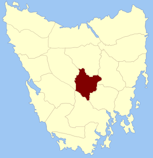
The Cumberland Land District is a special area in Tasmania, an island state in Australia. It's one of twenty "land districts" that help divide up the land for official purposes. Think of it like a historical way of mapping out different parts of the state. It used to be known as one of the 18 "counties" of Tasmania.
This district has natural borders like rivers and lakes. To the south, you'll find the River Derwent. The Clyde River forms its eastern edge. At the north-eastern side, there's a big lake called Lake Sorell. On the western side, the Nive River marks the boundary. Part of the Shannon River and Great Lake are on its northern border.
How Tasmania Was Divided
On January 15, 1836, George Arthur, who was the Lieutenant Governor of Van Diemen's Land (which is now Tasmania), made an important announcement. He used a newspaper called The Hobart Town Courier to tell everyone about the first counties and parishes that would be surveyed. Surveying means carefully measuring and mapping out land.
The County of Cumberland
Governor Arthur officially described the County of Cumberland like this:
- It was bordered on the north by the county of Westmoreland.
- The Clyde River was its eastern border.
- A part of the Nive River formed its western border, all the way to where it joins the River Derwent.
- The River Derwent itself was the border to the southwest.
Hundreds and Parishes
When the land was divided, smaller areas called "hundreds" and "parishes" were also created. These were like smaller neighborhoods or sections within the larger counties.
Here are some of the hundreds and parishes that were named in Cumberland at that time:
- The hundred of Lawrenny
- Lawrenny parish
- Guilford parish
- Abergavenny parish
- Amhurst parish
- The hundred of Ebrington
- Fortescue parish
- Saint Albans parish
- Malmsbury parish
- Rochford parish
Several small towns were also officially recognized as being within the county. These included Neville, Ebrington, Burford, and Rochford. These divisions helped the government manage the land and its people better.
 | DeHart Hubbard |
 | Wilma Rudolph |
 | Jesse Owens |
 | Jackie Joyner-Kersee |
 | Major Taylor |

