Somerset Land District facts for kids
Quick facts for kids SomersetTasmania |
|||||||||||||||
|---|---|---|---|---|---|---|---|---|---|---|---|---|---|---|---|

Location in Tasmania
|
|||||||||||||||
|
|||||||||||||||
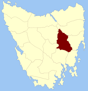
The Somerset Land District is a special area in Tasmania, Australia. It's one of twenty "land districts" used to help organize and describe land. Think of it like a historical way to divide up the land for maps and records. It used to be known as one of the 18 "counties" in Tasmania.
Contents
How Land Was Divided in Early Tasmania
Long ago, when Tasmania was first being settled by Europeans, the government needed a way to keep track of all the land. They decided to divide it into smaller sections. This helped with mapping, selling land, and managing the growing colony.
The First Land Divisions: Counties and Parishes
On January 15, 1836, the leader of the island, Lieutenant Governor George Arthur, announced how the land would be divided. He used newspapers like The Hobart Town Courier to share this important news.
He created "counties" and then split these counties into even smaller areas called "parishes" and "hundreds." These were like different-sized puzzle pieces that made up the whole map of Tasmania.
What Was Somerset County Like?
The original County of Somerset had clear boundaries. It was bordered by rivers like the South Esk and the Clyde. It also included parts of the Eastern Tier mountains and even some lakes like Crescent and Sorell. These natural features helped people understand where one area ended and another began.
Towns in the Old Somerset County
Many towns that you might know today were part of the original Somerset County. Some of these included Perth, Campbelton, Ross, and Oatlands. These towns were important centers for people living in the county.
 | Charles R. Drew |
 | Benjamin Banneker |
 | Jane C. Wright |
 | Roger Arliner Young |

