
Glamorgan Land District facts for kids
Quick facts for kids GlamorganTasmania |
|||||||||||||||
|---|---|---|---|---|---|---|---|---|---|---|---|---|---|---|---|

Location in Tasmania
|
|||||||||||||||
|
|||||||||||||||
The Glamorgan Land District is one of the twenty special areas in Tasmania used for mapping and keeping land records. It's like a big section of land on a map. This area used to be called one of the 18 counties of Tasmania.
Glamorgan is located on the eastern side of Tasmania. It stretches from a place called Seymour in the north down to Pontypool in the south. This district includes well-known towns like Swansea, Bicheno, Cranbrook, and Lisdillon. It also covers the beautiful Great Oyster Bay, the Freycinet Peninsula, and Schouten Island. The local government area called Glamorgan Spring Bay Council covers a very similar region.
How Glamorgan Was Created
Back in the day, on January 15, 1836, a very important person named George Arthur made an official announcement. He was the Lieutenant Governor of Van Diemen's Land, which is what Tasmania was called back then. He announced the very first counties and parishes that would be mapped out in the colony.
He officially stated that the County of Glamorgan would be bordered by Cornwall to the north and Somerset to the west. To the east, it would meet the Pacific Ocean. The Little Swanport River would form its southern border. This new county also included all the islands along the east coast, like the Schouten Islands and other islands in Oyster Bay.
Early Land Divisions
When Glamorgan was first created, it was divided into smaller sections. These sections were called "hundreds" and "parishes." These were older ways of organizing land for things like taxes and records.
At that time, only one "hundred" was named, called Eastbourne. Underneath it, there were two named parishes:
- Eastbourne parish
- Glastonbury parish
Some other parishes were planned but not named yet. The towns of Eastbourne and part of Avoca were also officially part of this new county.
Images for kids
-
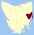
Location of Glamorgan Land District in Tasmania.
