Curlwaa, New South Wales facts for kids
Quick facts for kids CurlwaaNew South Wales |
|
|---|---|

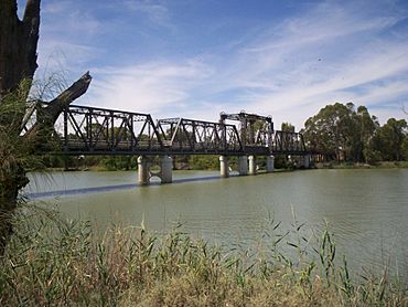
Abbotsford Bridge
|
|
| Population | 393 (2016 census) |
| Postcode(s) | 2648 |
| Location | 4 km (2 mi) east of Wentworth |
| LGA(s) | Wentworth Shire |
| State electorate(s) | Murray |
| Federal Division(s) | Farrer |
Curlwaa is a small place in New South Wales, right next to the famous Murray River. It's home to the historic Abbotsford Bridge. Big roads like the Silver City Highway and Calder Highway pass through Curlwaa. This makes it super easy to reach from the city of Mildura in Victoria.
Contents
What is Curlwaa?
Curlwaa is a special farming area called an 'irrigation settlement'. It's located a few kilometers upstream from Wentworth on the Murray River. This area is in the far southwest of New South Wales. What makes Curlwaa really interesting is that it was the very first government-planned irrigation project in New South Wales. It was started way back in 1890!
Discovering the Abbotsford Bridge
The Abbotsford Bridge is a cool old bridge that crosses the Murray River. It connects Yelta, Victoria with Curlwaa in New South Wales. This bridge is the most northern point where you can cross the river. It's also the very last crossing point before you reach the South Australia border. That border is about 109 kilometers (67 miles) to the west.
Where Did the Name Come From?
The name "Abbotsford" comes from a ferry service that used to operate there. This service was called "Abbot's Ford". Over time, this part of the river, which is northwest of Merbein, became known as Abbotsford.
When Was the Bridge Opened?
The Abbotsford Bridge was officially opened on July 10, 1928. A very important person, Admiral Sir Dudley de Chair, who was the Governor of New South Wales at the time, opened it.


