
Cuyamaca, California facts for kids


Cuyamaca is a special area in eastern San Diego County, California. It's located near the Laguna Mountains, south of Julian and north of Descanso. The name comes from an old land grant called Rancho Cuyamaca from 1845.
Today, the area is mostly covered by the huge Cuyamaca Rancho State Park, which is about 26,000 acres (105 square kilometers). Inside this park, you'll find Cuyamaca Peak. This peak is the second-tallest mountain in San Diego County, standing at 6,512 feet (1,985 meters) high.
The name "Cuyamaca" comes from the Kumeyaay language. The original Kumeyaay phrase was ‘Ekwiiyemak. Some people say it means "Behind the clouds," while others translate it as "the place where it rains." This second meaning makes sense because Cuyamaca gets more rain than the lower coastal areas of San Diego County. You might see the name Cuyamaca used for streets, businesses, and even a college in the San Diego area.
Contents
History of Cuyamaca
During the Julian Gold Rush, a gold mine called the Stonewall Mine was discovered. It was on the south side of what is now Lake Cuyamaca.
Early Mining Towns
First, there was a mining camp called Stonewall from 1873 to 1876. Later, it became a company town named Stratton from 1887 to 1888. This town was then renamed Cuyamaca City and existed until 1906. At its busiest, Cuyamaca City had about 500 people living there. It was the main town serving the Stonewall Mine.
In 1906, the post office in Cuyamaca City closed. Mail services moved to Descanso. After the gold mining stopped, the town was abandoned. Today, there are very few signs left of the old town. The spot where Cuyamaca City once stood is now part of Cuyamaca Rancho State Park.
Modern Cuyamaca Community
A newer community of Cuyamaca grew on the north side of Lake Cuyamaca. Before a big fire in 2003, this community had about 145 homes. These homes were located on a mountain called North Peak, which is north of the lake.
The Cedar Fire of 2003
In October 2003, a very large wildfire called the Cedar Fire swept through the Cuyamaca region. This fire caused a lot of damage.
Nearly 25,000 acres (101 square kilometers) of the state park were burned. Also, 120 homes in the Cuyamaca community were destroyed by the fire. The historic Dyer Ranch house, which was used as a museum and the park's main office, was also lost in the blaze.
Images for kids
-
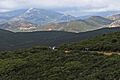
Cuyamaca Mountains "behind the clouds" and Stonewall Peak, seen from the Laguna Mountains
-
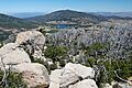
Lake Cuyamaca seen from Stonewall Peak
-
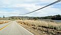
CA 79 looking north with Lake Cuyamaca on the right
See also
 In Spanish: Cuyamaca (California) para niños
