Dalola facts for kids
Quick facts for kids
Dalola
|
|
|---|---|

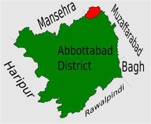
Location of Dalola Union Council (highlighted in red) within Abbottabad District, the names of the neighbouring districts to Abbottabad are also shown.
|
|
| Country | |
| Province | Khyber Pakhtunkhwa |
| District | Abbottabad |
| Tehsil | Abbottabad |
| Population | |
| • Total | 18,900 |
Dalola is one of the 51 Union Councils (sub-divisions) of Abbottabad District in the Khyber Pakhtunkhwa province of Pakistan. A Union Council is a local government area that helps manage services for the people living there.
Where is Dalola Located?
Dalola is found at specific coordinates: 34°21'20N latitude and 73°23'50E longitude. It sits about 798 meters (2,618 feet) above sea level. This makes it quite high up!
It is in the northwest part of the Abbottabad District. In fact, it's the most northern area of the district. Dalola shares its borders with the Mansehra District to the north. It also borders the Muzaffarabad District of Kashmir to the east. A big earthquake affected Dalola in 2005.
What are Dalola's Subdivisions?
The Dalola Union Council is divided into smaller areas. These areas help organize the region for local administration. The main parts of Dalola are Dabban, Daloa, and Naroka.

