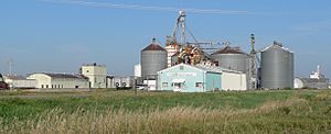
Darr, Nebraska facts for kids
Quick facts for kids
Darr, Nebraska
|
|
|---|---|
 |
|
| Country | United States |
| State | Nebraska |
| County | Dawson |
| Elevation | 2,451 ft (747 m) |
| Time zone | UTC-6 (Central (CST)) |
| • Summer (DST) | UTC-5 (CDT) |
| Area code(s) | 308 |
| GNIS feature ID | 828579 |
Darr is a small place in Nebraska, United States. It's called an unincorporated community. This means it's a group of homes and businesses that isn't officially a town or city with its own local government. Darr is located in Dawson County.
You can find Darr along two main roads: U.S. Route 30 and Nebraska Highway 21. It sits between the towns of Cozad and Lexington. Darr is quite high up, about 2,451 feet (747 meters) above sea level. You can even spot Darr on a special map made by the USGS, which is a government agency that studies the Earth.
History of Darr
Darr has a short but interesting history. It was named after a person named George B. Darr. He was the first owner of the land where the community was built.
The Post Office in Darr
A post office was opened in Darr in the year 1902. A post office is a place where people can send and receive mail. It's also where they can buy stamps. This post office helped the people living in Darr get their letters and packages. However, the post office in Darr did not stay open forever. It closed down in 1923, after being in operation for 21 years.
 | Percy Lavon Julian |
 | Katherine Johnson |
 | George Washington Carver |
 | Annie Easley |


