Davis Sea facts for kids
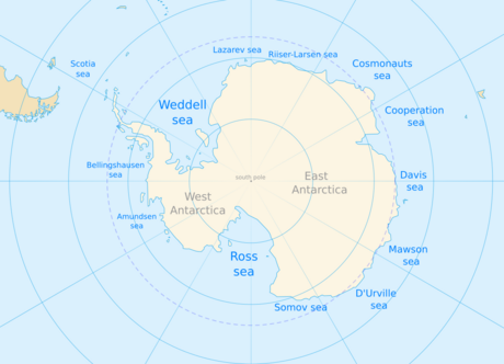
The Davis Sea is a fascinating part of the Southern Ocean, located right off the coast of East Antarctica. Imagine a vast stretch of water bordered by huge sheets of ice called the West Ice Shelf to the west and the Shackleton Ice Shelf to the east. This sea is so important that you can find its name on many major maps and atlases, like those from the National Geographic Society and the Times Atlas of the World.

This icy sea is quite deep, reaching down to about 1,300 meters (that's over 4,200 feet!). Its surface area is around 21,000 square kilometers, though some maps show it as a bit smaller. The Davis Sea touches the shores of several interesting parts of Antarctica, including the Leopold and Astrid Coast, Kaiser Wilhelm II Land, and Queen Mary Land. To its west, you might find another proposed sea called the Cooperation Sea.
Contents
Discovering the Davis Sea
The Davis Sea was first explored and named by the brave members of the Australian Antarctic Expedition. This journey took place between 1911 and 1914, using a ship called the Aurora. The leader of the expedition, Sir Douglas Mawson, decided to name this sea in honor of his trusted captain, John King Davis. Captain Davis was not only the master of the Aurora but also the second-in-command of the entire expedition. It was a great way to remember his important role in exploring this remote part of the world.
Features of the Davis Sea
This cold ocean is home to some unique geographical features. About 55 kilometers (around 34 miles) off the coast of Queen Mary Land, you'll find Drygalski Island. This island is a significant landmark in the area.
Coastal Landmarks
Along the shores of the Davis Sea, there are other interesting spots. The Roscoe Glacier flows directly into the eastern part of the sea, adding fresh ice to its waters. Close to the coast, you can also spot Bigelow Rock and the Gillies Islands. These small landforms are important for navigation and understanding the local geology.
Research in the Davis Sea Region
The Davis Sea is a vital area for scientific research. In 1956, Russia established the Mirny Station right on the coast of Queen Mary Land. This station has been a base for scientists studying the weather, ice, and marine life in this extreme environment for many decades. Research stations like Mirny help us learn more about Antarctica and how it affects our planet.
See also
- Davis Station
- Tressler Bank
 | Delilah Pierce |
 | Gordon Parks |
 | Augusta Savage |
 | Charles Ethan Porter |

