De Soto, Georgia facts for kids
Quick facts for kids
De Soto, Georgia
|
|
|---|---|

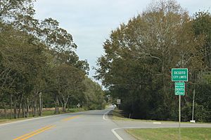
GA30/US280EB, Desoto City limit
|
|

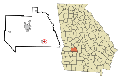
Location in Sumter County and the state of Georgia
|
|
| Country | United States |
| State | Georgia |
| County | Sumter |
| Government | |
| • Type | Mayor-council government |
| Area | |
| • Total | 0.82 sq mi (2.11 km2) |
| • Land | 0.82 sq mi (2.11 km2) |
| • Water | 0.00 sq mi (0.00 km2) |
| Elevation | 308 ft (94 m) |
| Population
(2020)
|
|
| • Total | 124 |
| • Density | 151.96/sq mi (58.71/km2) |
| Time zone | UTC-5 (Eastern (EST)) |
| • Summer (DST) | UTC-4 (EDT) |
| ZIP code |
31743
|
| Area code(s) | 229 |
| FIPS code | 13-22472 |
| GNIS feature ID | 0355464 |
De Soto is a small city in Sumter County, Georgia, in the United States. It is part of the Americus area. In 2020, about 124 people lived there.
History of De Soto
De Soto was officially made a town in 1889 by the Georgia government. The community is named after Hernando de Soto. He was an explorer who is famous for discovering the Mississippi River.
Geography of De Soto
De Soto is located at 31°57′17″N 84°4′3″W / 31.95472°N 84.06750°W. This means it's in a specific spot on the map.
The city covers a total area of about 0.8 square miles (2.1 square kilometers). All of this area is land, with no water.
Population and People
| Historical population | |||
|---|---|---|---|
| Census | Pop. | %± | |
| 1900 | 250 | — | |
| 1910 | 228 | −8.8% | |
| 1920 | 216 | −5.3% | |
| 1930 | 373 | 72.7% | |
| 1940 | 295 | −20.9% | |
| 1950 | 309 | 4.7% | |
| 1960 | 282 | −8.7% | |
| 1970 | 321 | 13.8% | |
| 1980 | 248 | −22.7% | |
| 1990 | 258 | 4.0% | |
| 2000 | 214 | −17.1% | |
| 2010 | 195 | −8.9% | |
| 2020 | 124 | −36.4% | |
| U.S. Decennial Census 1850-1870 1870-1880 1890-1910 1920-1930 1940 1950 1960 1970 1980 1990 2000 2010 2020 |
|||
In 2000, there were 214 people living in De Soto. These people lived in 78 households, and 53 of those were families. By the year 2020, the population of De Soto had changed to 124 people.
See also
 In Spanish: De Soto (Georgia) para niños
 | Tommie Smith |
 | Simone Manuel |
 | Shani Davis |
 | Simone Biles |
 | Alice Coachman |

