Dedham, Maine facts for kids
Quick facts for kids
Dedham, Maine
|
|
|---|---|
| Country | United States |
| State | Maine |
| County | Hancock |
| Villages | Dedham Green Lake Lucerne-in-Maine |
| Area | |
| • Total | 44.38 sq mi (114.94 km2) |
| • Land | 39.33 sq mi (101.86 km2) |
| • Water | 5.05 sq mi (13.08 km2) |
| Elevation | 344 ft (105 m) |
| Population
(2020)
|
|
| • Total | 1,648 |
| • Density | 42/sq mi (16.2/km2) |
| Time zone | UTC-5 (Eastern (EST)) |
| • Summer (DST) | UTC-4 (EDT) |
| ZIP Code |
04429
|
| Area code(s) | 207 |
| FIPS code | 23-16935 |
| GNIS feature ID | 0582436 |
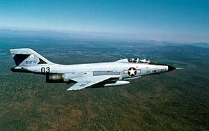
Dedham is a small town in Maine, United States. It is located in Hancock County. In 2020, about 1,648 people lived there. Dedham is also known for a Cold War airplane crash that happened on Bald Mountain.
Contents
Geography of Dedham
Dedham covers an area of about 44.38 square miles (114.94 square kilometers). Most of this area is land, about 39.33 square miles (101.86 square kilometers). The rest, about 5.05 square miles (13.08 square kilometers), is water.
Lucerne-in-Maine Village
Inside Dedham, there is a small village called Lucerne-in-Maine. This area is a popular summer resort. It is located near Phillips Lake. Lucerne-in-Maine is part of Dedham. However, it has some special rules. It can collect taxes and make some decisions on its own.
The Lucerne-in-Maine Village Corp. was created in 1927. This was done to give summer residents a say in how the village was run. The village continues to operate this way today.
History of Dedham
Dedham, Maine, got its name from another town. It was named after Dedham, Massachusetts.
1961 Airplane Crash on Bald Mountain
On April 11, 1961, during the Cold War, two McDonnell F-101 Voodoo fighter planes took off. They were from Dow Air Force Base. Their mission was to check on an unknown aircraft. This aircraft was flying towards the United States.
Soon after they took off, it was discovered the unknown aircraft was a friendly bomber. The fighter planes were told to return to base. It was raining lightly, which made the runway icy. There were also low clouds.
One of the planes landed safely. But the second plane crashed into Bald Mountain. Both pilots on board were killed. Investigators later found that the plane's altimeter (which measures height) was set incorrectly. This caused a 1000-foot error.
Population of Dedham
The number of people living in Dedham has changed over time. Here is a look at the population from 1840 to 2020.
| Historical population | |||
|---|---|---|---|
| Census | Pop. | %± | |
| 1840 | 455 | — | |
| 1850 | 546 | 20.0% | |
| 1860 | 495 | −9.3% | |
| 1870 | 448 | −9.5% | |
| 1880 | 406 | −9.4% | |
| 1890 | 366 | −9.9% | |
| 1900 | 327 | −10.7% | |
| 1910 | 353 | 8.0% | |
| 1920 | 286 | −19.0% | |
| 1930 | 279 | −2.4% | |
| 1940 | 293 | 5.0% | |
| 1950 | 374 | 27.6% | |
| 1960 | 438 | 17.1% | |
| 1970 | 522 | 19.2% | |
| 1980 | 841 | 61.1% | |
| 1990 | 1,229 | 46.1% | |
| 2000 | 1,422 | 15.7% | |
| 2010 | 1,681 | 18.2% | |
| 2020 | 1,648 | −2.0% | |
| U.S. Decennial Census | |||
Dedham Population in 2010
In 2010, there were 1,681 people living in Dedham. These people lived in 702 households. About 491 of these were families. The town had about 42.7 people per square mile. There were 1,254 housing units in total.
Most people in Dedham were White (97.6%). A small number were African American, Native American, or Asian. Some people were of Hispanic or Latino background.
About 26.6% of households had children under 18. Most households (58.1%) were married couples. The average household had 2.39 people. The average family had 2.76 people.
The average age in Dedham was 46.2 years. About 19.3% of residents were under 18. About 11.8% were 65 or older. The town had slightly more males (51.5%) than females (48.5%).
See also
 In Spanish: Dedham (Maine) para niños
 | May Edward Chinn |
 | Rebecca Cole |
 | Alexa Canady |
 | Dorothy Lavinia Brown |


