Deer Creek, Arizona facts for kids
Quick facts for kids
Deer Creek, Arizona
|
|
|---|---|

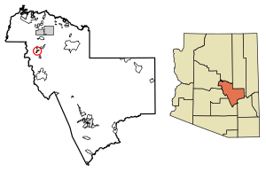
Location of Deer Creek in Gila County, Arizona.
|
|
| Country | United States |
| State | Arizona |
| County | Gila |
| Area | |
| • Total | 1.83 sq mi (4.74 km2) |
| • Land | 1.83 sq mi (4.74 km2) |
| • Water | 0.00 sq mi (0.00 km2) |
| Elevation | 3,025 ft (922 m) |
| Population
(2020)
|
|
| • Total | 230 |
| • Density | 125.75/sq mi (48.55/km2) |
| Time zone | UTC-7 (Mountain (MST)) |
| ZIP code |
85541
|
| Area code(s) | 928 |
| GNIS feature ID | 2582770 |
Deer Creek is a small community in Gila County, Arizona. It is a special area called a census-designated place. This means it is defined by the government for counting people.
Deer Creek is located almost directly between the community of Tonto Basin and the town of Payson. It is also found near Arizona State Route 87. In 2020, about 230 people lived in Deer Creek.
Geography of Deer Creek
Deer Creek is located at specific coordinates. These are 34.062342 degrees North and 111.349481 degrees West. The community covers an area of about 4.74 square kilometers (1.83 square miles). All of this area is land.
There is a real creek named Deer Creek that flows near this community. Sometimes, the creek can be dry. A well-known pioneer named David Gowan was buried near the North Fork of Deer Creek. This spot is close to Bars Canyon. Today, his grave site is marked and protected.
Population of Deer Creek
| Historical population | |||
|---|---|---|---|
| Census | Pop. | %± | |
| 2020 | 230 | — | |
| U.S. Decennial Census | |||
The population of Deer Creek was counted in the 2020 U.S. Census. At that time, 230 people lived in the community. This number helps us understand how many people live in different areas.
See also
 In Spanish: Deer Creek (Arizona) para niños
 | Kyle Baker |
 | Joseph Yoakum |
 | Laura Wheeler Waring |
 | Henry Ossawa Tanner |


