Deerfield Street, New Jersey facts for kids
Quick facts for kids
Deerfield Street, New Jersey
|
|
|---|---|
| Country | |
| State | |
| County | Cumberland |
| Township | Upper Deerfield |
| Area | |
| • Total | 1.76 sq mi (4.55 km2) |
| • Land | 1.76 sq mi (4.55 km2) |
| • Water | 0.00 sq mi (0.00 km2) |
| Elevation | 115 ft (35 m) |
| Population
(2020)
|
|
| • Total | 230 |
| • Density | 130.98/sq mi (50.57/km2) |
| Time zone | UTC−05:00 (Eastern (EST)) |
| • Summer (DST) | UTC−04:00 (EDT) |
| ZIP Code |
08313
|
| Area code(s) | 856 |
| FIPS code | 34-16960 |
| GNIS feature ID | 2806069 |
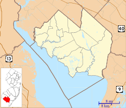
Deerfield (also known as Deerfield Street) is a small community in New Jersey, a state in the United States. It's found within Upper Deerfield Township, which is in Cumberland County.
Deerfield is known as an "unincorporated community." This means it's a recognized area, but it doesn't have its own separate local government like a city or town. Instead, it's part of the larger Upper Deerfield Township. It's also a "census-designated place" (CDP), which means the U.S. Census Bureau has defined it as a specific area for gathering population data. It was first listed as a CDP in the 2020 census.
Where is Deerfield?
Deerfield is located on New Jersey Route 77. This road helps connect it to other places. It's about 6.6 miles (10.6 km) north of a larger town called Bridgeton.
The community has its own post office that uses the name Deerfield Street. The ZIP Code for Deerfield is 08313.
How Many People Live Here?
According to the 2020 United States census, the population of Deerfield was 230 people. This number helps us understand how many residents live in this small community.
 | Sharif Bey |
 | Hale Woodruff |
 | Richmond Barthé |
 | Purvis Young |


