
Del Valle Regional Park facts for kids
Quick facts for kids Del Valle Regional Park |
|
|---|---|
.jpg)
Del Valle Regional Park and Lake
|
|
| Location | Alameda County, California |
| Nearest city | Livermore, California |
| Area | 4,316 acres |
| Created | 1968 |
| Operated by | East Bay Regional Parks District |
| Status | Open |
Del Valle Regional Park is a beautiful outdoor area. It is part of the East Bay Regional Park District (EBRPD). This park is located in an area of Alameda County, California, about 10 miles (16 km) south of Livermore. The park is very large, covering 4,316 acres. That's about 17.5 square kilometers!
Contents
Exploring the Park
About the Park's Nature
The park is mostly built around Lake Del Valle. This lake was made in 1968 by building a dam on a small river called Arroyo Valle. The lake is a great place for fun activities. You can go swimming, fishing, and boating here. There are even lifeguards in the special swimming areas to keep everyone safe.
Del Valle Regional Park also has many trails. There are about 28 miles (45.1 km) of trails. You can use these trails for hiking, riding horses, or biking. The park also has 150 places where you can set up a tent and go camping. It is also the start of the Ohlone Wilderness Trail. This long trail connects to Sunol and Mission Peak Regional Parks.
Park Trails
Like many parks in the East Bay, Del Valle has lots of trails. One popular trail is the East Shore Trail. It starts near Arroyo Road and goes up to a ridge. Then it follows the lake for several miles toward the boat launch area. The Sailor Camp Trail leads to the Ohlone Wilderness Trail. Another trail goes to Mendenhall Road. Most trails climb up hills around the lake. They usually stay between 500 to 1,500 feet (150 to 460 m) high.
How to Get to the Park
By Car
You can drive to the park using Del Valle Park Road or Arroyo Road. Del Valle Road connects to the southern part of the park. Arroyo Road leads to the northern entrance.
You can reach Mines Road from Tesla Road (which is also called J2). Arroyo Road can be reached from Concannon Boulevard and Wetmore Road.
By Foot
You can also walk to the Arroyo entrance. There is a narrow path that connects to Sycamore Grove Park. This path is part of the larger trail system managed by the Livermore Area Recreation and Park District (LARPD).

Park History and Weather
How the Park Started
Workers began building Lake Del Valle in 1966. The lake was finished in 1968. Del Valle Regional Park first opened to visitors in 1970. This was 36 years after the East Bay Regional Park District was created in 1934.
Weather Challenges
California Drought
In the early to mid-2010s, California had a very serious drought. A drought means there is not enough rain. This drought caused 12 million trees in California to die. The East Bay Regional Park District wrote an article to help people understand the drought.
Flooding in 2017
Soon after the drought, Del Valle Regional Park had a lot of damage. This was from very heavy rains in early 2017. The rain was caused by a weather pattern called La Niña. Much of the damage was around Lake Del Valle. Water from the lake overflowed five times into beaches, campgrounds, and picnic areas. Some of the trails were washed away and had to be rebuilt. The park was closed for almost three months. It reopened on April 15, 2017. Park officials thought it would cost a lot of money to fix the park.
Flooding in 2019
In early 2019, heavy rains came to the Del Valle Regional Park area again. Because of this, the park closed in the middle of February 2019. It was planned to open again in early March.
Algae in the Lake
Sometimes, Lake Del Valle has had problems with harmful algae. Algae are tiny plant-like things that grow in water. During the winter of 2015-2016, swimming was not allowed in the lake because of this algae.
Images for kids
-
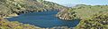
Lake Del Valle reservoir, within Del Valle Regional Park in the Diablo Range, Alameda County, San Francisco Bay Area, California.
-
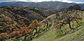
Del Valle Regional Park - Eagle Crest Trail
-

Del Valle Regional Park - Eagle Crest Trail
-
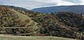
Del Valle Regional Park - Ridgeline Trail
-
Del Valle Regional Park - Cedar Mountain
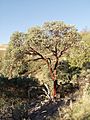
Arctostaphylos glauca — bigberry manzanita -
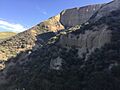
Cliffs at the northern end of Del Valle Regional Park


