Deloraine, Manitoba facts for kids
Quick facts for kids
Deloraine
|
|
|---|---|

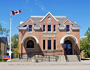
The post office in Deloraine, constructed 1930
|
|
| Country | Canada |
| Province | Manitoba |
| Village | March 1, 1904 |
| Town | May 1, 1907 |
| Amalgamation | January 1, 2015 |
| Area | |
| • Metro | 2.54 km2 (0.98 sq mi) |
| Population
(2016)
|
|
| • City | 978 |
| • Density | 385.7/km2 (999/sq mi) |
| Time zone | UTC−05:00 (CST) |
| • Summer (DST) | UTC−06:00 (CDT) |
| Website | http://delowin.ca/ |
Deloraine is a small community in Manitoba, Canada. It's located in the southwestern part of the province, close to the Turtle Mountains. Deloraine is about 100 kilometers (62 miles) south of Brandon.
It used to be a town, but in 2015, it joined with the Rural Municipality of Winchester to form the Municipality of Deloraine – Winchester. The community gets its name from a village in Roxburghshire, Scotland.
Contents
Discovering Deloraine's Past
The land around Deloraine was originally home to Indigenous peoples like the Assiniboine and Hunkpapa. Their lives were closely connected to the large herds of plains bison that roamed the area.
How Deloraine Got Its Name
In 1883, a small settlement began to grow. A man named James Cavers opened a general store and post office. He named it Deloraine after his home district in Scotland. This is how the community got its name!
The Arrival of the Railway
The railway changed everything for Deloraine. In 1884, the Canadian Pacific Railway built tracks north of the original town site. By 1886, the railway connected Deloraine to Boissevain and then eastward.
Because the railway was so important, the entire town decided to move! Over about a month in late 1886, shops, mills, blacksmiths, and even the post office packed up. They all moved to the new location right next to the railway tracks.
Deloraine quickly became a major hub for shipping grain. It even received grain from places as far away as Carnduff. Passenger trains also ran, connecting Deloraine to other communities and even to Winnipeg.
Growing the Community
The Canadian government worked hard to encourage people to settle in the area. Many Belgian families arrived in 1888 and even more in 1892. By 1893, most of the land was settled.
People also built churches. A methodist church was built in 1897, but sadly, it burned down in 1951. A new one was built in its place. Another church, the Deloraine Presbyterian Church, was built around the same time and still stands today.
Deloraine officially became a village in 1904 and then a town in 1907. Later, in 1920, Mennonite families also settled in the area. Chinese Canadians also played a big part in the town, often running restaurants and laundries.
Tough Times and Big Changes
The Great Depression in the 1930s was a very difficult time for Deloraine, like many other places. Money was scarce, and jobs were hard to find. However, the Canadian government helped by building a new post office in 1930. This project brought some much-needed work to the community. Things started to get better around 1939.
World War II also had a huge impact on Deloraine. People worked hard to raise money and sell "victory bonds" to support the war effort. Many young men from Deloraine went overseas to fight.
When the war ended in 1945, the community celebrated with a huge party! Over 1,000 students from 31 local schools joined a big "Field Day" in Deloraine. It was a joyful day of victory and peace.
In 2015, Deloraine joined with the Rural Municipality of Winchester. This change was part of a plan to combine smaller local governments in Manitoba.
Exploring Deloraine's Surroundings
Deloraine is located near Whitewater Lake. This lake is a bit salty and its water levels can change a lot depending on how much rain falls.
Just south of Deloraine are the Turtle Mountains. This is a raised area of land, like a plateau, that stands about 90 to 120 meters (295 to 394 feet) higher than the land around it. Part of this area is protected as Turtle Mountain Provincial Park, which is a great place to explore nature.
Deloraine's Weather
Deloraine experiences all four seasons, with warm summers and cold winters. Here's a look at the average temperatures and precipitation:
| Climate data for Deloraine Climate ID: 5010760; coordinates 49°11′N 100°30′W / 49.183°N 100.500°W; elevation: 500.5 m (1,642 ft); 1971-2000 normals |
|||||||||||||
|---|---|---|---|---|---|---|---|---|---|---|---|---|---|
| Month | Jan | Feb | Mar | Apr | May | Jun | Jul | Aug | Sep | Oct | Nov | Dec | Year |
| Record high °C (°F) | 7.8 (46.0) |
16.5 (61.7) |
21.7 (71.1) |
35.0 (95.0) |
41.1 (106.0) |
37.5 (99.5) |
40.6 (105.1) |
38.5 (101.3) |
38.3 (100.9) |
32.0 (89.6) |
21.1 (70.0) |
16.1 (61.0) |
41.1 (106.0) |
| Mean daily maximum °C (°F) | −9.7 (14.5) |
−6.7 (19.9) |
0.6 (33.1) |
11.2 (52.2) |
19.3 (66.7) |
23.5 (74.3) |
26.1 (79.0) |
25.4 (77.7) |
18.6 (65.5) |
11.5 (52.7) |
0.3 (32.5) |
−7.9 (17.8) |
9.3 (48.7) |
| Daily mean °C (°F) | −15.5 (4.1) |
−12.2 (10.0) |
−4.7 (23.5) |
4.9 (40.8) |
12.6 (54.7) |
17.1 (62.8) |
19.5 (67.1) |
18.5 (65.3) |
12.2 (54.0) |
5.4 (41.7) |
−4.5 (23.9) |
−13.2 (8.2) |
3.3 (37.9) |
| Mean daily minimum °C (°F) | −21.3 (−6.3) |
−17.6 (0.3) |
−9.9 (14.2) |
−1.3 (29.7) |
5.8 (42.4) |
10.6 (51.1) |
12.8 (55.0) |
11.6 (52.9) |
5.7 (42.3) |
−0.9 (30.4) |
−9.2 (15.4) |
−18.5 (−1.3) |
−2.7 (27.1) |
| Record low °C (°F) | −43.3 (−45.9) |
−46.1 (−51.0) |
−39.4 (−38.9) |
−31.1 (−24.0) |
−10.0 (14.0) |
−3.3 (26.1) |
−1.1 (30.0) |
−3.0 (26.6) |
−7.8 (18.0) |
−21.0 (−5.8) |
−33.3 (−27.9) |
−41.5 (−42.7) |
−46.1 (−51.0) |
| Average precipitation mm (inches) | 19.6 (0.77) |
14.3 (0.56) |
24.4 (0.96) |
33.8 (1.33) |
49.9 (1.96) |
85.3 (3.36) |
67.4 (2.65) |
58.5 (2.30) |
51.2 (2.02) |
33.9 (1.33) |
20.6 (0.81) |
19.3 (0.76) |
478.1 (18.82) |
| Average rainfall mm (inches) | 0.4 (0.02) |
0.3 (0.01) |
3.7 (0.15) |
22.8 (0.90) |
47.8 (1.88) |
85.3 (3.36) |
67.4 (2.65) |
58.5 (2.30) |
50.7 (2.00) |
24.2 (0.95) |
4.1 (0.16) |
0.8 (0.03) |
366.0 (14.41) |
| Average snowfall cm (inches) | 19.1 (7.5) |
14.0 (5.5) |
20.7 (8.1) |
11.0 (4.3) |
2.1 (0.8) |
0.2 (0.1) |
0.0 (0.0) |
0.0 (0.0) |
0.5 (0.2) |
9.8 (3.9) |
16.5 (6.5) |
18.5 (7.3) |
112.3 (44.2) |
| Average precipitation days (≥ 0.2 mm) | 7.00 | 5.70 | 5.60 | 5.40 | 8.30 | 11.00 | 9.70 | 8.60 | 8.70 | 5.30 | 5.40 | 6.10 | 86.70 |
| Average rainy days (≥ 0.2 mm) | 0.13 | 0.17 | 0.74 | 3.50 | 8.00 | 11.00 | 9.70 | 8.60 | 8.50 | 4.00 | 0.95 | 0.09 | 55.30 |
| Average snowy days (≥ 0.2 cm) | 6.90 | 5.60 | 5.10 | 2.40 | 0.48 | 0.04 | 0.00 | 0.00 | 0.26 | 1.80 | 4.50 | 6.00 | 32.90 |
| Source: Environment and Climate Change Canada | |||||||||||||
Deloraine's Population
In 2021, Deloraine had a population of 962 people. These people lived in 441 homes. The community covers a land area of about 2.52 square kilometers (0.97 square miles).
Fun Things to See and Do
Deloraine has some interesting attractions:
- One of only two old stone bank vaults still standing in western Canada.
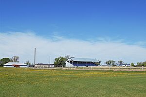
- A 1/2-mile track where exciting harness races take place in the summer.
- Prairie Sentinels Park, which features the Flags of the World project.
How Deloraine Works: Water and More
Getting fresh water was a challenge in the early days. People had to drill deep wells. After some very dry years in the 1930s, a large water reservoir was built in 1963. This gave the community a reliable source of clean drinking water.
The community also has a system for treating wastewater. This treated water then flows into Whitewater Lake.
Famous Faces from Deloraine
Some notable people have connections to Deloraine:
- Ashton Bell, a hockey player
- Ronald D. Bell, a judge
- James Bissett, a diplomat
- William Morton, a tenor singer
- Rick Neufeld, a musician
 | Frances Mary Albrier |
 | Whitney Young |
 | Muhammad Ali |


