Delridge, Seattle facts for kids
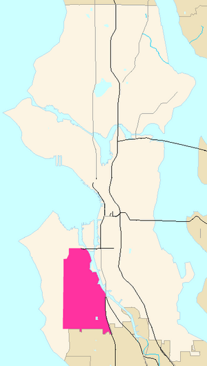
Delridge is a cool area in Seattle, Washington. It's a district that follows a main road called Delridge Way. This road goes along the eastern side of the Longfellow Creek valley, from the city's southern edge all the way north to the West Seattle Bridge. Delridge is often thought of as part of or very close to West Seattle.
This area is mostly made up of homes and green spaces. It sits between two ridges: one where South Seattle College is, and another where the High Point neighborhood is located. The city of Seattle also uses "Delridge" to talk about a bigger group of neighborhoods nearby. This larger area isn't strictly defined, but it's generally bordered by the Duwamish River to the north and east, White Center to the south, and West Seattle to the west.
Some of the neighborhoods often included in the broader Delridge area are Pigeon Point, Youngstown, Puget Ridge, Riverview, High Point, Highland Park, Westwood, and Roxhill. There are also some industrial areas near the river.
Contents
What are the neighborhoods in Delridge?
Delridge is made up of several unique neighborhoods. Here are some of them:
- Cottage Grove
- High Point
- Highland Park
- North Delridge
- Pigeon Point
- Puget Ridge
- Riverview
- Roxhill
- Snake Hill
- South Delridge
- Westwood
- Youngstown
Cottage Grove
Cottage Grove was first planned out between 1918 and 1923. It's generally located south of Youngstown. You can find the Youngstown Cultural Arts Center here, even though its name suggests it's in Youngstown!
High Point
High Point gets its name because it's the highest spot in Seattle, reaching 520 feet (about 158 meters) above sea level! It's well-known for a housing project that used to be there. This project provided homes for many refugees and immigrants when they first arrived in Seattle.
Highland Park
Highland Park has traditionally been a neighborhood where many working-class families lived. This was because it was close to places like Boeing Field and other job sites in the Industrial District. Today, it's a very diverse neighborhood, with people from many different backgrounds. Westcrest Park is a great spot nearby, with an off-leash area for dogs.
Pigeon Point
The Pigeon Point neighborhood is on a high bluff, or cliff, just south of the West Seattle Bridge. It overlooks the southern part of Elliott Bay. This neighborhood is home to Pathfinder K-8 at Cooper, a local school.
Puget Ridge
The Puget Ridge neighborhood is south of Pigeon Point and is surrounded by lots of green spaces. It's home to Puget Creek, Puget Park, Puget Ridge Edible Park (where you can find plants you can eat!), and Sanislo Elementary School.
Riverview
The Riverview neighborhood is just south of South Seattle College. It's home to Riverview Playfield park, which is a big park with many tennis courts, baseball fields, soccer fields, and a football field for sports and fun.
Roxhill
Roxhill is mostly a residential area, meaning it has many homes. It also has a main area for shops and businesses. You can find green spaces like Roxhill Park here, and Longfellow Creek flows right through it.
Snake Hill
Snake Hill is located between Camp Long and High Point. It's west of Longfellow Creek.
Westwood
The source of Longfellow Creek, which is a partially restored wetland, is located in Westwood.
Westwood is also home to a large shopping area called Westwood Village. You can find popular stores like Target, Bed Bath and Beyond, Staples, and Marshall's here. Many new townhomes are also being built in this neighborhood.
Youngstown
The Youngstown neighborhood is a low-lying area where Longfellow Creek flows into the Duwamish River estuary. In the early 1900s, this neighborhood was built for the immigrant steelworkers who worked at the nearby Seattle Steel mill.
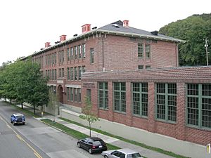
The Youngstown Cultural Arts Center opened in 2006. It's located in the old Frank B. Cooper School building, which was built in 1917. This old school building is now listed on the National Register of Historic Places because of its important history.
|
 | Aaron Henry |
 | T. R. M. Howard |
 | Jesse Jackson |


