Dennery District facts for kids
Quick facts for kids
Dennery
|
|
|---|---|
|
District
|
|

View of Dennery Bay
|
|
 |
|
| Country | St. Lucia |
| Area | |
| • Total | 72.3 km2 (27.93 sq mi) |
| Population
(2010)
|
|
| • Total | 12,767 |
| • Density | 177/km2 (457/sq mi) |
| ISO 3166-2:LC |
LC-05
|
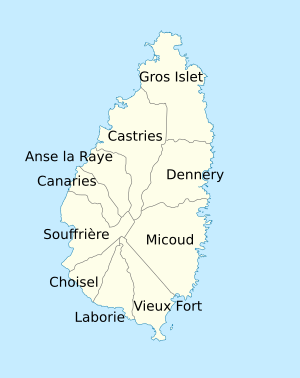
Dennery District is one of the ten main areas, or districts, on the beautiful Caribbean island nation of Saint Lucia. The main town in this district is called Dennery Village. People here mostly earn a living through fishing. They also grow crops like lima beans, bananas, and other tasty tropical fruit. In 2010, about 12,767 people lived in the Dennery District.
Contents
History of Dennery
Before it was called Dennery, this area had other names. It was known as Anse Canot, which means "Bay of canoes." It was also called Le Grand Mabouya.
The district was later named after Count d'Ennery. He was an author who wrote about Saint Lucia in the 1760s. He also became the Governor-General of the Windward Islands from 1766 to 1770.
Geography of Dennery District
The Dennery District is divided into 49 smaller areas. These are called second-order administrative divisions.
A large part of Dennery District is in the Mabouya Valley. This valley includes places like Derniere Riviere, Aux Lyon, Despinoze, Gadette, Grand Riviere, Grand Ravine, La Ressource, and Richfond.
Just a few kilometers offshore to the south of the town is Frigate Island Nature Reserve. This island is a special protected area.
Other interesting places in the Dennery District include:
- Anse Galet (a bay), 13°53′27″N 60°52′52″W / 13.89072°N 60.88117°W
- Anse Louvet (a bay), 13°57′47″N 60°52′39″W / 13.96319°N 60.87747°W
- Anse Povert (a bay), 13°56′35″N 60°52′35″W / 13.9431°N 60.87643°W
- Aux Lyon (a mountain), 13°57′16″N 60°54′20″W / 13.95452°N 60.90555°W
- Aux Lyon (a town), 13°56′45″N 60°54′28″W / 13.94583°N 60.9078°W
- Barra Estate, 13°56′47″N 60°55′22″W / 13.94643°N 60.92285°W
- Des Bateaux Island, 13°55′01″N 60°52′44″W / 13.91686°N 60.87902°W
- Dennery Bay, 13°54′26″N 60°53′10″W / 13.90711°N 60.88611°W
- Dennery Island, 13°54′32″N 60°53′03″W / 13.90886°N 60.88425°W
- Dennery Waterworks Forest Reserve, 13°53′30″N 60°55′05″W / 13.89179°N 60.91804°W
- Dernière Rivière (a town), 13°57′14″N 60°55′28″W / 13.95377°N 60.92433°W
- Dennery Village, 13°54′40″N 60°53′28″W / 13.91099°N 60.89122°W
- Dennery River, 13°54′30″N 60°53′26″W / 13.90822°N 60.89052°W
- Errard Estate, 13°53′43″N 60°56′01″W / 13.89514°N 60.93356°W
- Fond d'Or Bay (mouth), 13°55′19″N 60°53′10″W / 13.92207°N 60.88619°W
- Fond d'Or River (mouth), 13°55′23″N 60°53′25″W / 13.92303°N 60.89027°W
- Grande Rivière du Mabouya, 13°56′10″N 60°54′31″W / 13.93622°N 60.90859°W
- Mount La Combe, 13°54′51″N 60°57′30″W / 13.91411°N 60.95841°W, which is 419 meters high.
- Piton Canarie (a mountain), 13°51′19″N 61°01′01″W / 13.85524°N 61.01687°W, which is 632 meters high.
- Sault Falls, a 20-meter high waterfall on the Dennery River.
- Rouche Island, 13°57′12″N 60°52′28″W / 13.95324°N 60.87433°W
- Saint Joseph Estate, 13°54′10″N 60°55′04″W / 13.9028°N 60.91781°W
- Frigate Island Nature Reserve, 13°52′46″N 60°53′01″W / 13.8794°N 60.88366°W. This reserve is managed by the Saint Lucia National Trust. It is an important place where seabirds come to breed.
Dennery Fish Fiesta
Every Saturday, the Dennery village hosts a fun event called the Dennery Fish Fiesta. It runs from 4:00 PM to 2:00 AM. Both tourists and local people come to try different local foods. These foods are mostly made with fresh seafood, especially fish.
You can find fresh seafood, baked goods, rum punch, and Piton beer at the stalls. There is also a live DJ playing music. This event is closed during the Lenten season.
Government in Dennery
The main town of Dennery is where the district's government is located.
The Dennery District is divided into two areas for elections. These areas choose people to represent them in the House of Assembly of Saint Lucia. Since July 2021, Shawn A. Edward represents Dennery North. Paul Prospere represents Dennery South. They were chosen during the country's recent general election.
See also
 In Spanish: Distrito de Dennery para niños
- Geography of Saint Lucia
- List of cities in Saint Lucia
- List of rivers of Saint Lucia
- Districts of Saint Lucia

