Denson Seamount facts for kids
Quick facts for kids Denson Seamount |
|
|---|---|

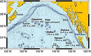
Map of the Kodiak-Bowie Seamount chain
|
|

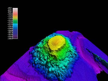
A 3D picture of Denson Seamount, looking northwest
|
|
| Location | |
| Location | North Pacific Ocean |
| Coordinates | 54°03′34″N 137°25′01″W / 54.0594°N 137.4170°W |
| Country | United States |
| Geology | |
| Type | Submarine volcano |
| Volcanic arc/chain | Kodiak-Bowie Seamount chain |
| Age of rock | 18 million years old |
Denson Seamount is an underwater volcano located in the Pacific Ocean. It is part of a long line of underwater mountains called the Kodiak-Bowie Seamount chain. This seamount is about 18 million years old. It sits near the border between Canada and the United States.
In 2004, scientists explored Denson Seamount during an expedition. They wanted to learn more about the geology of five unknown seamounts in the Gulf of Alaska.
Exploring Denson Seamount
A seamount is a mountain that rises from the ocean floor but does not reach the surface. Denson Seamount was one of the underwater volcanoes studied by the 2004 Gulf of Alaska Seamount Expedition. The main goal of this trip was to understand the history of these underwater mountains.
Scientists created detailed maps of each seamount. They also collected rock samples from different depths. This helped them learn how these underwater mountains formed and changed over time.
Discovering its Age
On August 6, 2004, a special submarine called the DSV Alvin went down to Denson Seamount. Its mission was to collect volcanic rocks called basalt. These rocks would help scientists figure out the seamount's age.
It was hard to find good samples because the salty ocean water had changed the rocks over millions of years. But after testing the rocks in a lab, the team found that Denson Seamount was about 18 million years old.
Mapping the Underwater World
The scientists used a method called bathymetric mapping. This technique uses sound waves to create detailed, three-dimensional pictures of the ocean floor. It's like making a map of the underwater landscape.
This mapping helped them see the shape of Denson Seamount and the areas around it. It gave them a clear picture of this ancient underwater volcano.
 | Jessica Watkins |
 | Robert Henry Lawrence Jr. |
 | Mae Jemison |
 | Sian Proctor |
 | Guion Bluford |

