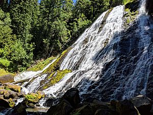
Diamond Creek Falls facts for kids
Quick facts for kids Diamond Creek Falls |
|
|---|---|
 |
|
| Lua error in Module:Infobox_mapframe at line 185: attempt to index field 'wikibase' (a nil value). | |
| Location | Willamette National Forest |
| Coordinates | 43°36′26″N 122°08′36″W / 43.60722°N 122.14333°W |
| Type | Veiling Horsetail |
| Elevation | 4,195 ft (1,279 m) |
| Total height | 120 ft (37 m) |
Diamond Creek Falls is a beautiful waterfall found in the amazing Willamette National Forest in Oregon. It's located on the east side of Oakridge, a city in Lane County, Oregon. This stunning waterfall is formed along Gibson Canyon.
Diamond Creek Falls is a special type of waterfall called a "Veiling Horsetail." This means the water spreads out like a thin curtain as it falls, looking a bit like a horse's tail. The waterfall drops an impressive 120 ft (37 m), which is about as tall as a 12-story building! You can easily visit Diamond Creek Falls by following trail paths from Oregon Route 58. These paths lead you right down to the stream and the base of the waterfall.
Contents
Discovering Diamond Creek Falls: The Trail Adventure
Ready for an adventure? The journey to Diamond Creek Falls starts from a parking lot. Look for the interpretive kiosk, which gives you information about the area. To the left of this kiosk, you'll find the beginning of a 3.4-mile (5 km) loop hike. This trail is part of both the Salt Creek Falls and Diamond Creek Falls trails.
Starting Your Hike
The Salt Creek Falls trail begins with a paved path. It follows along Salt Creek, leading you to a nice picnic area. This is a great spot to take a break or have a snack before continuing your hike.
Choosing Your Path
After the picnic area, you'll cross a bridge over Salt Creek. Beyond the bridge, the trail divides into two paths. One path leads to Salt Creek Falls, but to reach Diamond Creek Falls, you'll want to take the path to the right.
Reaching the Viewpoint
Following the right path means a quick climb for about 0.2 miles (0 km). This short uphill walk leads you to an amazing viewpoint. From here, you can see wide views of the surrounding canyon, offering a perfect photo opportunity!
Continuing to the Falls
Past this viewpoint, the Diamond Creek Falls Trail continues for about 1.1 miles (2 km). Along this part of the trail, you'll pass by a small lake called Too Much Bear Lake. Eventually, the trail leads to a junction. This junction is your final turn towards the waterfall.
At the Base of the Falls
From the junction, you can access the base of Diamond Creek Falls. The path down involves walking over natural basalt steps, through fissures (cracks in the rock), and around large boulders. It's a fun and exciting way to get up close to the powerful waterfall!
 | James Van Der Zee |
 | Alma Thomas |
 | Ellis Wilson |
 | Margaret Taylor-Burroughs |

