Salt Creek Falls facts for kids
Quick facts for kids Salt Creek Falls |
|
|---|---|
 |
|
| Lua error in Module:Infobox_mapframe at line 185: attempt to index field 'wikibase' (a nil value). | |
| Location | Lane County, Oregon |
| Coordinates | 43°36′42″N 122°07′43″W / 43.61179°N 122.12861°W |
| Type | Cascade, Plunge |
| Elevation | 3,902 ft (1,189 m) |
| Total height | 286 ft (87 m) |
| Number of drops | 1 |
| Average width | 40 ft (12 m) |
| Watercourse | Salt Creek |
| Average flow rate |
6,684 cu ft/s (189.3 m3/s) |
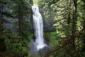
Salt Creek Falls is a beautiful waterfall in Oregon. It's located on Salt Creek, which flows into the Middle Fork Willamette River. The waterfall drops into a deep canyon near Willamette Pass in the Willamette National Forest.
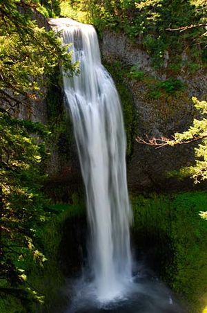
This waterfall is special because its main drop is 286 feet (87 m) high. This makes it one of the tallest plunge waterfalls in Oregon. Only Multnomah Falls and Watson Falls are taller. The water lands in a pool that is about 20 metres (66 ft) deep.
Contents
What is Salt Creek Falls Like?
Salt Creek Falls drops about 286 feet (87 m). Its height stays pretty much the same because of the large rocks at the top. The water flow is sometimes broken by rocks sticking out.
On average, about 250 cubic feet per second (7.1 m3/s) of water flows over the falls each year. The top of the waterfall is 3,902 ft (1,189 m) above sea level. The water flow is strongest in late spring or early summer. This is when the mountain snow melts. There are no dams or diversions on Salt Creek at the falls.
How Did Salt Creek Falls Form?
Salt Creek Falls was created a long time ago. This happened when glaciers melted during the last ice age. Water from new lakes carved a valley through the forest. The main glacier made the canyon deeper. This left side valleys much higher than the river floor.
Later, lava flowed into part of this valley. This created the narrow canyon walls you see today. These walls are made of a rock called columnar basalt.
Who Discovered Salt Creek Falls?
The first people to describe Salt Creek Falls were Frank S. Warner and Charles Tufti. Frank Warner lived in Lane County his whole life. Charles Tufti was a Native American of Molala ancestry. They reported seeing the falls in March 1887.
The waterfall gets its name from Salt Creek. This creek has salty springs downstream. Wildlife often visit these springs to lick the salt.
Hoodoo Recreation Services manages Salt Creek Falls and its visitor areas. In 2018, The Oregonian newspaper called Salt Creek Falls one of Oregon's 50 most beautiful places.
Where is Salt Creek Falls Located?
Salt Creek Falls is in the middle of the Cascade Range. It's part of the Willamette National Forest. It's also next to the Salt Creek Sno-park and Too Much Bear Lake. The falls are about 4 miles (6.4 km) west of Willamette Pass. They are also about 22 miles (35 km) upstream from where Salt Creek joins the Middle Fork Willamette River. The falls start with small cascades before the big 286-foot (87 m) drop. The total height of the falls is over 87 metres (285 ft).
How to Get to Salt Creek Falls
You can easily reach Salt Creek Falls by car all year. Just take Oregon Route 58. This road connects U.S. Route 97 near Chemult with Interstate 5 near Eugene. The day use area is about 21 miles (34 km) east of Oakridge. It's also about 5 miles (8.0 km) west of Willamette Pass.
The U.S. Forest Service charges a $5 fee to park for the day. But if you have a Northwest Forest Pass, you don't need to pay. There's a viewing platform near the top of the falls. You can also hike down to the bottom.
What Hiking Trails Are There?
The Salt Creek Falls Trail offers two main paths. Both start at the information kiosk in the parking lot. They both go up about 400 ft (122 m) in height.
Salt Creek Falls Loop Hike
One option is a 3.4-mile (5 km) loop hike. It starts to the left of the kiosk. The trail follows Salt Creek on a paved path to a picnic area. After the picnic area, a bridge crosses Salt Creek.
The trail then splits. If you go right, you'll climb quickly for about 0.2 miles (0 km). This leads to a wide view of the canyon. From there, the Diamond Creek Falls Trail continues for about 1.1 miles (2 km). It passes Too Much Bear Lake. This trail ends at a junction that leads to Diamond Creek Falls. You can reach the base of Diamond Creek Falls by walking down basalt steps and over rocks.
 | Kyle Baker |
 | Joseph Yoakum |
 | Laura Wheeler Waring |
 | Henry Ossawa Tanner |


