Dientes de Navarino facts for kids
Quick facts for kids Dientes de Navarino |
|
|---|---|

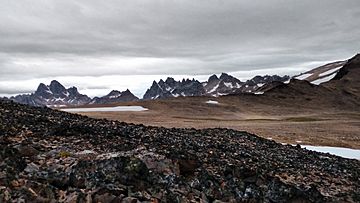
View of Dientes de Navarino from Cerro Bandera on February 14 (summer), 2016
|
|
| Highest point | |
| Peak | Pico Navarino |
| Elevation | 1,195 m (3,921 ft) |
| Dimensions | |
| Length | 30 km (19 mi) north-south |
| Geography | |
| Country | Chile |
| State/Province | Magallanes |
| Range coordinates | 55°1′S 67°39′W / 55.017°S 67.650°W |
| Parent range | Andes |
The Dientes de Navarino (which means Teeth of Navarino in English) is a mountain range. It is located on Navarino Island in Chile. These mountains are just south of Puerto Williams, near the Beagle Channel coast. They are called "teeth" because their sharp peaks look like jagged teeth.
There is a challenging hiking path around these mountains. This journey usually takes 5 to 7 days. The exact time depends on the weather.
An Australian climber and writer named Clem Lindenmayer first created this trail in the 1990s. In 2001, the Chilean government honored him. They named two peaks along the route after him: Cerro Clem and Montes Lindenmayer. Clem Lindenmayer also wrote a famous travel guide called Lonely Planet Trekking in the Patagonian Andes.
Beavers and the Environment
In the 1940s, the government of Argentina brought beavers to Tierra del Fuego. They hoped to start a successful fur trade. However, there were no animals that hunted beavers in this area. Because of this, the beavers quickly grew in number and spread widely.
The forests around the Dientes de Navarino mountains were not ready for so many beavers. Beavers cut down trees to build their dams and lodges. This has caused a lot of damage to the forests. Many lake shores near the mountains have lost all their trees because of the beavers.
See also

- In Spanish: Dientes de Navarino para niños
- Martial Mountains
- Cordillera Darwin
- Marinelli Glacier
 | May Edward Chinn |
 | Rebecca Cole |
 | Alexa Canady |
 | Dorothy Lavinia Brown |

