Navarino Island facts for kids
|
Native name:
Isla Navarino or Shunuko (Yamana)
|
|
|---|---|

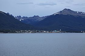
Puerto Williams and as background, Dientes de Navarino
|
|
| Geography | |
| Coordinates | 55°04′32″S 67°39′19″W / 55.0755°S 67.6553°W |
| Adjacent bodies of water | Pacific ocean - Atlantic ocean |
| Area | 2,473 km2 (955 sq mi) |
| Highest elevation | 1,195 m (3,921 ft) |
| Highest point | Dientes de Navarino |
| Administration | |
| Region | Magallanes |
| Province | Antártica Chilena |
| Commune | Cabo de Hornos, Chile |
| Demographics | |
| Population | ~2,000 |
| Additional information | |
| NGA UFI=-893346 | |
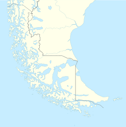
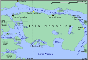
Navarino Island (called Isla Navarino in Spanish) is a Chilean island located at the very bottom of South America. It sits between a larger island called Isla Grande de Tierra del Fuego to the north and Cape Horn to the south. This island is part of the Cabo de Hornos area, which is the southernmost part of Chile and the world! Most of the people living on Navarino Island live in Puerto Williams. Other smaller towns include Puerto Navarino, Río Guanaco, and Puerto Toro. The highest point on the island is Pico Navarino, which is 1,195 meters (3,921 feet) tall. Navarino Island is a popular spot for people who enjoy fly fishing.
Contents
Navarino Island is very important for understanding history and archaeology. It has one of the highest numbers of ancient sites in the world. The Yahgan were a group of nomadic people who lived here long ago. They moved their homes depending on the season. Their old trash piles, called middens, show that they ate a lot of fish and shellfish. They also gathered some plants.
Near Wulaia Bay, archaeologists found a very old Yahgan site. It dates back about 10,000 years! They found remains of huts surrounded by ring-shaped middens. These middens are like ancient recycling piles.
Many visitors come to learn about the Yahgan culture. The Martin Gusinde Anthropological Museum on the island shows how the Yahgan people lived. You can see their homes, fishing tools, and crafts. The museum also has items from English Christian missions from the 1800s. People also visit to see the island's birds, unique rocks, and plants.
The waters around Navarino Island were once part of a disagreement between Chile and Argentina. This happened in 1958 and was called the Snipe incident. It was about who owned a small, uninhabited islet called Snipe. This incident was part of a bigger problem called the Beagle Conflict, which almost led to war in 1978. Both countries had different ideas about where the border was in the Beagle Channel.
The first Europeans to land on Navarino Island were from Jacques l'Hermite's fleet in 1624. They wrote down the native name of the island as Wulla. Later, the ship HMS Beagle visited the island in 1829. This ship was commanded by Phillip Parker King and Robert FitzRoy. They named the island after the Battle of Navarino, which happened in 1827. This battle was a big moment in the Greek War of Independence against the Ottoman Empire.
The coast of Navarino Island is perfect for sea kayaking. You can paddle among small islands and channels. These areas are full of native plants and many different kinds of birds.
If you like fishing, you can find great spots in the Murray Channel. You can also take boat trips to see the amazing glaciers. These glaciers are in the northwest part of the Beagle Channel, inside Alberto de Agostini National Park. Boat trips also go towards Cape Horn and Chilean Antarctica.
For hikers, there's a challenging trail around the spiky mountains called the Dientes de Navarino. This trail goes past peaks like Cerro Clem and Montes Lindenmayer. These peaks were named in 2001 by the Chilean government. There are also places for rock climbing on the island.
Many ranches have been built on Navarino Island. The northern part of the island is great for horseback riding. You can find lots of salmon trout in Navarino Lake. On the north coast, the sea forms deep coves where you can fish for snook.
Navarino Island has a tundra climate, which is a type of polar climate. In the northern coastal area, where Puerto Williams is located, it rains about 467 millimeters (18 inches) each year. The average temperature there is 6°C (43°F). The warmest month averages 9.6°C (49°F), and the coldest month averages 1.9°C (35°F).
Further south, it rains more, about 800 millimeters (31 inches) per year. The temperatures are a bit cooler there. Rain falls pretty evenly throughout the year, and some of it comes down as snow. In the far southern part of the island, including Lakes Navarino and Windhond, there is even more rain. Summer temperatures are lower, and winter temperatures are higher due to strong winds.
| Climate data for Navarino Island | |||||||||||||
|---|---|---|---|---|---|---|---|---|---|---|---|---|---|
| Month | Jan | Feb | Mar | Apr | May | Jun | Jul | Aug | Sep | Oct | Nov | Dec | Year |
| Mean daily maximum °C (°F) | 12.3 (54.1) |
12.4 (54.3) |
11.7 (53.1) |
9.1 (48.4) |
6.9 (44.4) |
5.0 (41.0) |
5.0 (41.0) |
5.1 (41.2) |
7.5 (45.5) |
9.8 (49.6) |
10.5 (50.9) |
11.8 (53.2) |
9.0 (48.2) |
| Daily mean °C (°F) | 9.8 (49.6) |
9.3 (48.7) |
8.4 (47.1) |
6.1 (43.0) |
3.8 (38.8) |
2.6 (36.7) |
2.2 (36.0) |
1.8 (35.2) |
3.9 (39.0) |
6.2 (43.2) |
7.2 (45.0) |
9.6 (49.3) |
5.9 (42.6) |
| Mean daily minimum °C (°F) | 5.2 (41.4) |
6.0 (42.8) |
4.6 (40.3) |
2.9 (37.2) |
1.0 (33.8) |
−0.5 (31.1) |
0.0 (32.0) |
−0.3 (31.5) |
1.0 (33.8) |
2.9 (37.2) |
4.1 (39.4) |
5.0 (41.0) |
2.7 (36.9) |
| Average precipitation mm (inches) | 51.9 (2.04) |
44.1 (1.74) |
40.8 (1.61) |
38.3 (1.51) |
44.3 (1.74) |
26.6 (1.05) |
34.8 (1.37) |
42.8 (1.69) |
26.2 (1.03) |
25.7 (1.01) |
33.6 (1.32) |
38.7 (1.52) |
450.8 (17.75) |
| Average relative humidity (%) | 79 | 85 | 81 | 81 | 83 | 84 | 87 | 91 | 86 | 84 | 83 | 84 | 84 |
| Source: Bioclimatografia de Chile | |||||||||||||
The northern part of the island has a type of forest called deciduous Magellanic forest. Here, you'll find trees like Lenga Beech (Nothofagus pumilio). In drier spots, there's Ñirre Beech (Nothofagus antarctica). In wetter areas, you'll see Coihue of Magallanes (Nothofagus betuloides). There are also some shrubs and Magellanic moorland in places where water doesn't drain well.
Just south of this area is the evergreen Magellanic rainforest. This forest likely grows here because of more rain, higher elevation, and better drainage. The main tree here is Nothofagus betuloides (Coihue of Magallanes). It often grows in pure groups in higher areas or on windy coasts.
The southern part of the island, around Lakes Navarino and Windhond, has Magellanic moorland plants. This includes different plant groups like the Esfagnosa Tundra (Sphagnum magellanicum) and the Pulvinada Tundra (Donatia fascicularis - Astelia pumila).
At very high elevations, the land is like an Andean Desert. Here, there are no trees or tall shrubs. Less than 30% of the ground is covered by plants.
Like much of the surrounding Tierra del Fuego area, Navarino Island has a big problem with beavers. These beavers were brought from Canada to Tierra del Fuego in the 1940s. The Argentinian government wanted to start a fur trade. However, there were no animals to hunt the beavers, so they quickly spread to nearby islands.
The trees in Tierra del Fuego and Navarino Island are not used to beavers. They can't recover once the beavers cut them down.
Scientists from the University of North Texas studied Navarino Island. They found that the slow-moving water behind beaver dams has attracted two more animals that don't belong there: muskrats and minks. While minks hunt muskrats, they also eat native geese and ducks. This creates a chain reaction where one invasive species helps others, which scientists call an "invasive meltdown process."
Special Places and Culture
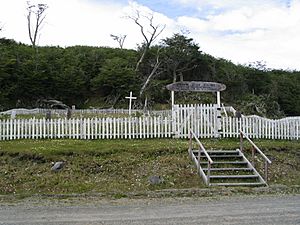
Important historical and cultural sites include Bahia Wulaia and the English Mission at Douglas Creek. The large Stirling House was a pre-made iron building brought from England in 1869. It was used by Anglican missionaries. It was moved several times before being set up for mission use at Douglas Creek. At the Yahgan cemetery in Baia Mejillones, you can see tombs from the early 1900s. They show a mix of different religious ideas.
Villa Ukika is a part of Puerto Williams where the last few Yamana people live. Other small towns are Puerto Navarino, which is a fishing port known for king crabs, and Puerto Toro. Puerto Toro claims to be the world's southernmost "settlement."
The area around Navarino Island and its nearby islands was named a UNESCO Biosphere Reserve in June 2005. It is called the Cabo de Hornos Biosphere Reserve. This means it's a special place where nature and people live together in a sustainable way.
You can fly to Puerto Williams from Punta Arenas with DAP Helicópteros. Flights go to the Guardiamarina Zañartu Airport every day except Sundays. There is also a ferry that sails once a week. This boat trip crosses the Strait of Magellan and other channels. The journey takes about 30 to 36 hours. As of January 2011, there was also a boat service between Ushuaia and Navarino Island.
- Río Guanaco
- Puerto Bevan
- Puerto Williams
- Puerto Navarino
- Caleta Eugenia
- Puerto Toro
- Villa Ukika
See also
 In Spanish: Isla Navarino para niños
 | Dorothy Vaughan |
 | Charles Henry Turner |
 | Hildrus Poindexter |
 | Henry Cecil McBay |


