
Puerto Toro facts for kids
Quick facts for kids
Puerto Toro
|
|
|---|---|
 |
|

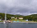
Puerto Toro at the east coast of Navarino Island
|
|

Puerto Toro
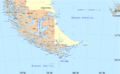
Location in Southern Patagonia

Puerto Toro
Location in Chile
|
|
| Country | |
| Region | |
| Province | Antártica Chilena |
| Municipalidad | Cabo de Hornos |
| Comuna | Cabo de Hornos |
| Government | |
| • Type | Municipalidad |
| Population
(2002 census [1])
|
|
| • Total | 36 |
| Time zone | UTC−3 (CLST) |
| Area code(s) | Country + town = 56 + ? |
Puerto Toro is a very small village, also called a hamlet, located on the eastern coast of Navarino Island in Chile. It was founded in 1892 by Governor Señoret of Punta Arenas. This happened during the exciting time of the Tierra del Fuego Gold Rush.
Puerto Toro is part of the Commune of Cabo de Hornos. This area is in the Antártica Chilena Province of the Magallanes y Antártica Chilena Region. This small community is special because it is the southernmost place on Earth where people live all the time. This excludes research stations in Antarctica. It is about 3,900 kilometers (2,425 miles) from the South Pole. Puerto Toro is also the only community like it that is located below the 55th parallel south.
According to a 2002 count, only 36 people live in Puerto Toro. These residents are mostly fishermen and their families. The International Hydrographic Organization says that Puerto Toro is the only Chilean town and port with coasts and waters that are part of the Atlantic Ocean. This is because of where the meridian of Cape Horn (67°16′ W) is located.
Contents
History of Puerto Toro
More than a hundred years ago, Puerto Toro was a very important town. It was a key spot in the Beagle Channel area. This was because of the Tierra del Fuego gold rush. Many people came looking for gold here.
However, once people lost interest in finding gold, Puerto Toro became less important. Its busy days faded away.
Life in Puerto Toro Today
Today, Puerto Toro is famous for its delicious "centolla." This is a special southern king crab that is highly valued. Fishing for this crab is a big part of life for the people here.
The village is also part of a special travel route called the End of the World Route. This scenic route shows off Puerto Toro as a unique southern point of Chile. It highlights the village's remote and beautiful location for visitors.
Climate and Weather
Puerto Toro has a cool climate, even though it is surrounded by forests. The winters are quite mild for such a southern location. The weather here is often described as a sub-Antarctic tundra climate.
| Climate data for Puerto Toro | |||||||||||||
|---|---|---|---|---|---|---|---|---|---|---|---|---|---|
| Month | Jan | Feb | Mar | Apr | May | Jun | Jul | Aug | Sep | Oct | Nov | Dec | Year |
| Mean daily maximum °C (°F) | 13.8 (56.8) |
13.6 (56.5) |
12.6 (54.7) |
10.1 (50.2) |
7.1 (44.8) |
5.5 (41.9) |
4.9 (40.8) |
5.1 (41.2) |
7.6 (45.7) |
10.1 (50.2) |
11.5 (52.7) |
13.6 (56.5) |
9.6 (49.3) |
| Daily mean °C (°F) | 9.3 (48.7) |
9.0 (48.2) |
8.2 (46.8) |
5.9 (42.6) |
3.5 (38.3) |
2.2 (36.0) |
1.8 (35.2) |
1.7 (35.1) |
3.8 (38.8) |
5.8 (42.4) |
7.1 (44.8) |
9.3 (48.7) |
5.6 (42.1) |
| Mean daily minimum °C (°F) | 4.9 (40.8) |
4.4 (39.9) |
3.8 (38.8) |
1.8 (35.2) |
0 (32) |
−0.9 (30.4) |
−1.2 (29.8) |
−1.6 (29.1) |
0 (32) |
1.6 (34.9) |
2.7 (36.9) |
5.1 (41.2) |
1.7 (35.1) |
| Average rainfall mm (inches) | 48 (1.9) |
46 (1.8) |
47 (1.9) |
50 (2.0) |
43 (1.7) |
37 (1.5) |
34 (1.3) |
40 (1.6) |
30 (1.2) |
29 (1.1) |
38 (1.5) |
45 (1.8) |
487 (19.2) |
| Source: Climate-Data.org | |||||||||||||
Images for kids
-
A view of Puerto Toro.
-
Map showing Puerto Toro's location at the southern tip of South America.
See also

