
Puerto Williams facts for kids
Quick facts for kids
Puerto Williams
|
|||||
|---|---|---|---|---|---|

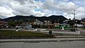
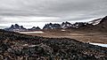
View of Puerto Williams with the Dientes de Navarino mountains (the 'Teeth of Navarino') in the background
|
|||||
|
|||||
| Country | |||||
| Region | |||||
| Province | Antártica Chilena | ||||
| Commune | Cabo de Hornos | ||||
| Founded as | Puerto Luisa | ||||
| Founded | 21 November 1953 | ||||
| Named for | John Williams Wilson | ||||
| Government | |||||
| • Type | Municipality | ||||
| Population
(2002)
|
|||||
| • Total | 2,874 | ||||
| Time zone | UTC−3 (CLST) | ||||


Puerto Williams (which means "Port Williams" in Spanish) is a city, port, and naval base located on Navarino Island in Chile. It is known as the southernmost populated place in the world. The city faces the Beagle Channel.
Puerto Williams is the capital of the Antártica Chilena Province, which is one of Chile's four provinces in the Magellan and Chilean Antarctica Region. It also manages the areas of Chilean Antarctic Territory and Cabo de Hornos. The city has a population of 2,874 people, including both navy members and civilians.
The settlement was started in 1953 and was first called Puerto Luisa. Later, it was renamed after John Williams Wilson. He was a British man who founded Fuerte Bulnes, the first settlement in the Strait of Magellan. Puerto Williams has mainly served as a naval base for Chile. The Chilean Navy runs the Guardiamarina Zañartu Airport and the local hospital. They also manage nearby weather stations.
Since the late 1900s, fewer navy people have lived in Puerto Williams, and more civilians have moved there. During this time, tourism and supporting scientific research have helped the local economy grow. The port attracts tourists who want to visit Cape Horn or Antarctica. Its tourism industry is built around being "the world's southernmost city."
Some people consider Puerto Williams the southernmost city in the world based on how they define a city. However, others disagree because of its small size and population. They often suggest Ushuaia or Punta Arenas instead. Still, Chilean and Argentine news, an agreement between Chile and Argentina, and the local government all call Puerto Williams the southernmost city in the world.
Puerto Williams is an important entry point and center for science related to Antarctica and the islands south of Isla Grande de Tierra del Fuego. The University of Magallanes has a study center here. Weather stations and lighthouses at Cape Horn and Diego Ramírez Islands get their supplies from Puerto Williams. The town helps Chile maintain its presence around Cape Horn and support its Antarctic bases.
The city also provides services for fishermen. The Navy is based here to help protect Chile's fishing rights in the ocean around southern Tierra del Fuego. Fishing for Lithodes santolla (a type of crab) is a very important business here.
Contents
History of Puerto Williams
The Yahgan people, who are native to southern Chile, are thought to have moved to this area over 10,000 years ago. They lived by hunting and gathering food. Europeans first found them and this area in the early 1500s. It wasn't until the 1800s that Europeans became interested in developing the area. Sometimes, towns here supplied ships that hunted whales.
In the late 1800s, gold was found in the region. This brought many people hoping to get rich. By 1890, about 300 gold miners were in the Picton, Lennox and Nueva islands and Puerto Toro, which was founded in 1892. Puerto Navarino, on the west side of Navarino Island, was started in June 1938. Also, some islands were used for raising sheep, and selling meat and wool became important.
Puerto Williams was founded in 1953. It was mainly built as a naval base for Chile. Its naval hospital opened in 1960. In 2002, a private company took over the electricity supply from the Chilean Navy.
According to a peace agreement between Chile and Argentina in 1984, Puerto Williams is the starting point for ships traveling between the Straits of Magellan and Argentine ports in the Beagle Channel.
Population Growth

Between 1982 and 2002, the number of people living in Puerto Williams grew from 1,059 to 2,874. Since 1982, Chile's National Statistics Institute has called Puerto Williams an "urban entity." However, they usually only call a place a "city" if it has more than 5,000 residents.
Fun Local Events
In the last week of May, Puerto Williams hosts a sailing competition. It attracts sailors from different countries. This competition is now in its 7th year and has over 300 participants each time. The race starts from the city's port and goes through the fjords. This event is part of the Chilean Navy's "Month of the Sea" activities. These activities remember the Naval Battle of Iquique from 1879.
Fiesta de la Nieve (Snow Festival)
In July, the city celebrates the winter season with a "Snow Festival." This celebration lasts for six days and includes snow games, car events, and rodeos.
Climate and Weather
The climate in Puerto Williams is a tundra climate. It is very close to a subpolar oceanic climate. Summers are short and cool, while winters are long, wet, but not too cold. About 512.3 mm (20 in) of rain falls each year, and temperatures stay fairly steady all year. Snow can even fall in the summer. The cool, wet summers help keep glaciers from melting. While the area around the town has many trees, higher or more open areas have a sub-Antarctic climate. This means it's like a tundra, where trees cannot grow.
| Climate data for Puerto Williams (Guardia Marina Zañartu Airport) 1991–2020, extremes 1968–present | |||||||||||||
|---|---|---|---|---|---|---|---|---|---|---|---|---|---|
| Month | Jan | Feb | Mar | Apr | May | Jun | Jul | Aug | Sep | Oct | Nov | Dec | Year |
| Record high °C (°F) | 25.2 (77.4) |
26.1 (79.0) |
24.0 (75.2) |
22.2 (72.0) |
17.5 (63.5) |
18.0 (64.4) |
15.9 (60.6) |
14.8 (58.6) |
18.6 (65.5) |
22.8 (73.0) |
24.2 (75.6) |
26.0 (78.8) |
26.1 (79.0) |
| Mean daily maximum °C (°F) | 15.4 (59.7) |
14.7 (58.5) |
14.8 (58.6) |
11.4 (52.5) |
8.5 (47.3) |
5.5 (41.9) |
5.7 (42.3) |
7.5 (45.5) |
9.7 (49.5) |
11.4 (52.5) |
12.9 (55.2) |
14.4 (57.9) |
11.0 (51.8) |
| Daily mean °C (°F) | 9.9 (49.8) |
9.6 (49.3) |
8.4 (47.1) |
6.2 (43.2) |
4.1 (39.4) |
1.9 (35.4) |
1.9 (35.4) |
2.9 (37.2) |
4.3 (39.7) |
6.1 (43.0) |
7.7 (45.9) |
8.7 (47.7) |
6.0 (42.8) |
| Mean daily minimum °C (°F) | 5.2 (41.4) |
5.0 (41.0) |
3.9 (39.0) |
1.7 (35.1) |
−0.6 (30.9) |
−1.6 (29.1) |
−2.0 (28.4) |
−0.8 (30.6) |
−0.2 (31.6) |
1.4 (34.5) |
2.3 (36.1) |
4.2 (39.6) |
1.5 (34.7) |
| Record low °C (°F) | −2.6 (27.3) |
−3.0 (26.6) |
−5.1 (22.8) |
−5.8 (21.6) |
−6.4 (20.5) |
−12.6 (9.3) |
−10.5 (13.1) |
−8.6 (16.5) |
−9.8 (14.4) |
−5.0 (23.0) |
−6.4 (20.5) |
−2.0 (28.4) |
−12.6 (9.3) |
| Average precipitation mm (inches) | 52.0 (2.05) |
53.2 (2.09) |
48.1 (1.89) |
40.0 (1.57) |
37.8 (1.49) |
45.3 (1.78) |
33.7 (1.33) |
36.0 (1.42) |
32.1 (1.26) |
30.1 (1.19) |
40.2 (1.58) |
48.1 (1.89) |
496.6 (19.55) |
| Average precipitation days (≥ 1.0 mm) | 10.6 | 9.4 | 8.2 | 7.3 | 6.9 | 7.6 | 7.0 | 6.2 | 6.3 | 6.9 | 8.2 | 9.9 | 94.5 |
| Source 1: Dirección Meteorológica de Chile | |||||||||||||
| Source 2: NOAA (precipitation days 1991–2020) | |||||||||||||
Tourism and Attractions
Tourism is one of the main ways people make money in Puerto Williams. Most places for tourists to stay are hostels. Several paths for multi-day hikes and backpacking trips have been made in the Dientes de Navarino mountains, which are south of Puerto Williams.
A five-day hiking trail goes around the sharp peaks known as the Dientes de Navarino (Teeth of Navarino). This trail passes peaks called Cerro Clem and Montes Lindenmayer. These were named in 2001 by the Chilean Ministry of Natural Resources.
You can find old campsites and fish traps from the Yahgan Indian people along the coast east of the city. Puerto Williams is also home to the Martin Gusinde Anthropological Museum. This museum shows how the Yahgan and Selk'nam lived. These groups were native to Tierra del Fuego. For an easy way to explore the subantarctic forest, the Omora Ethnobotanical Park is just five kilometers west of town.

Getting Around
You can get to Puerto Williams by flying daily from Guardiamarina Zañartu Airport. The airline Aerovías DAP provides this service. Another option is a weekly vehicle ferry, the Yaghan, which travels from Punta Arenas, about 350 kilometres (220 mi) to the north.
There isn't a regular public bus service. However, you can take smaller boats to Ushuaia on the main island of Tierra del Fuego in Argentina. This boat trip can be expensive.

Puerto Williams is one of the main naval bases for the Chilean Navy. This base is used as a starting point for patrols, scouting missions, and rescues. These operations cover the areas of the Beagle Channel, Cape Horn, Drake Passage, and the Antarctic Peninsula.
The Chilean Navy runs the Guardia Marina Zañartu Airport and the Naval Hospital in Puerto Williams. Navy personnel make up a large part of the city's population. However, their numbers have gone down in the 21st century.
The front part of the Yelcho is displayed at the Naval headquarters. The Yelcho was a tugboat used by Luis Pardo in the 1900s. It famously rescued Ernest Shackleton's men who were stuck on Elephant Island.
Services and Facilities
The city has a branch of Banco de Chile. It also has a fire station and a police station run by the Carabineros de Chile. Children in Puerto Williams go to a kindergarten, primary school, and secondary school. There is also a university center from the University of Magallanes.
Other important places include the Martin Gusinde Anthropological Museum, the airport, the seaport, and the Micalvi Yacht Club. Puerto Williams also has its own radio station, Radio Navarino.
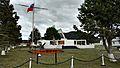
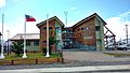
Gallery
-
O'Higgins Plaza.
-
Arturo Prat Plaza.
-
Municipality of Cabo de Hornos.
-
Antártica Chilena Province Governorate in Puerto Williams.
-
Dientes de Navarino From Cerro Bandera.
-
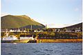
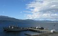
Puerto Williams from the port.
-
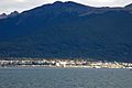
Puerto Williams from the Beagle Channel.
-
Puerto Williams in 1957.
-
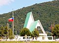
Catholic Church of Puerto Williams.
-
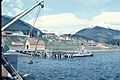
Naval base of Puerto Williams.
-
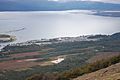
Puerto Williams from Cerro Bandera.


.jpg)
.jpg)

See also
 In Spanish: Puerto Williams para niños
