
Dietlikon facts for kids
Quick facts for kids
Dietlikon
|
||
|---|---|---|
 |
||
|
||

Dietlikon
Location in Switzerland

Dietlikon
Location in Canton of Zurich
|
||
| Country | Switzerland | |
| Canton | Zurich | |
| District | Bülach | |
| Area | ||
| • Total | 4.25 km2 (1.64 sq mi) | |
| Elevation | 445 m (1,460 ft) | |
| Population
(Dec 2020 )
|
||
| • Total | 7,875 | |
| • Density | 1,852.9/km2 (4,799/sq mi) | |
| Postal code |
8305
|
|
| Surrounded by | Bassersdorf, Dübendorf, Kloten, Wallisellen, Wangen-Brüttisellen | |

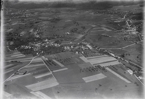
Dietlikon is a small town, also called a municipality, in Switzerland. It's located in the canton of Zürich, which is like a state. Dietlikon is part of the Bülach district.
This town is found in the beautiful Glatt Valley, known in German as Glattal. It's a great place to live, with a mix of history and modern life.
History of Dietlikon
Dietlikon was first mentioned in official records way back in 1124. At that time, it was called Dietlinchoven. For a long time, it was a quiet, sleepy village. It was nestled at the edge of the Hardwald forest.
The name "Dietlikon" tells us about its beginnings. Names ending in "-ikon" often come from the Alemanni, an ancient Germanic people. A clan leader named Dietilo, or Dieto, likely settled here. He probably chose this spot because there was water nearby.
The first people who lived here had to work very hard. They cleared parts of the forest to create space for farms. Names of fields like Rüti and Brand show how they changed the land. They even grew grapes to make wine. This wine, along with grain, was used to pay taxes.
Over the centuries, different groups owned parts of Dietlikon. These included the Allerheiligen monastery and the Wettingen monastery. Important historical figures, like Count Adalbert von Mörsburg and the Counts of Kyburg, were also linked to the area.
Geography and Nature
Dietlikon covers an area of about 4.2 square kilometers (1.6 square miles). A good part of this land, about 23.6%, is used for farming. This means there are fields where crops are grown.
About 31.1% of Dietlikon is covered by forests. These green spaces are important for nature and offer places to explore. Most of the remaining land, 44.1%, is developed with buildings and roads. A small part, 1.2%, is made up of rivers or other natural features.
The town is located on the edge of the middle Glatt Valley. This valley is known for its flat areas and gentle hills.
People and Population
Dietlikon is home to many people. As of 2022, its population was 7,855. The number of people living here has been growing steadily. Over the last 10 years, the population grew by about 18%.
Many different people live in Dietlikon. About 21.8% of the people living here are from other countries. Most people in Dietlikon speak German, which is the main language. Italian is the second most common language, followed by Serbo-Croatian.
The population includes people of all ages. About 20.5% are children and teenagers (under 19 years old). Adults (20-64 years old) make up 65.3% of the population. Seniors (over 64 years old) make up 14.2%. Many adults in Dietlikon have completed higher education.
Dietlikon has a low unemployment rate of 3.09%. This means most people who want to work can find jobs. The town has businesses in different areas. Some people work in farming, while many others work in manufacturing or services. The service sector, which includes things like shops and offices, has the most jobs.
Here's how the population has changed over time:
| year | population |
|---|---|
| 1467 | c. 115 |
| 1634 | 137 |
| 1771 | 482 |
| 1880 | 386 |
| 1900 | 565 |
| 1950 | 1,205 |
| 1970 | 4,381 |
| 2000 | 6,281 |
| 2022 | 7,855 |
Getting Around
Dietlikon is well-connected by public transport. The Dietlikon railway station is an important stop. It's part of the Zürich S-Bahn network. This is a system of commuter trains that connect Dietlikon to Zürich and other nearby towns.
You can catch trains like the S3, S8, and S19 from Dietlikon station. This makes it easy for people to travel for work, school, or fun.
See also
 In Spanish: Dietlikon para niños
