Dillonvale, Jefferson County, Ohio facts for kids
Quick facts for kids
Dillonvale, Ohio
|
|
|---|---|
|
Village
|
|

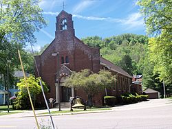
Saint Adalbert Roman Catholic Church on the corner of State Routes 150 and 152
|
|

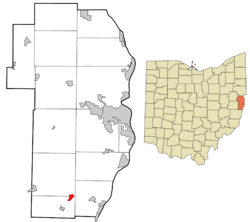
Location of Dillonvale in Jefferson County and in the state of Ohio
|
|
| Country | United States |
| State | Ohio |
| County | Jefferson |
| Townships | Mount Pleasant, Smithfield |
| Area | |
| • Total | 0.39 sq mi (1.02 km2) |
| • Land | 0.39 sq mi (1.00 km2) |
| • Water | 0.01 sq mi (0.02 km2) |
| Elevation | 774 ft (236 m) |
| Population
(2020)
|
|
| • Total | 589 |
| • Estimate
(2023)
|
599 |
| • Density | 1,525.91/sq mi (588.96/km2) |
| Time zone | UTC-5 (Eastern (EST)) |
| • Summer (DST) | UTC-4 (EDT) |
| ZIP code |
43917
|
| Area code(s) | 740 |
| FIPS code | 39-22022 |
| GNIS feature ID | 2398726 |
Dillonvale is a small village located in the southern part of Jefferson County, Ohio, in the United States. In 2020, about 589 people lived there. It's part of a larger area called the Weirton–Steubenville metropolitan area.
Contents
The Story of Dillonvale
Dillonvale wasn't always called that! It was first known as Annadelphia and was planned out in 1816. For a long time, not much happened in the town.
How Dillonvale Grew
Things changed when the Wheeling and Lake Erie Railway was built through the area in 1889. This railway helped the town grow. A new plan for the town was made, and it was given the name Dillon. Later, the name was changed to Dillonvale, which it still is today.
Where is Dillonvale Located?
Dillonvale is a small place. The United States Census Bureau says the village covers about 0.40 square miles (1.02 square kilometers). Most of this area is land, about 0.39 square miles (1.00 square kilometers). A very small part, about 0.01 square miles (0.02 square kilometers), is water.
Who Lives in Dillonvale?
The number of people living in Dillonvale has changed over the years.
| Historical population | |||
|---|---|---|---|
| Census | Pop. | %± | |
| 1910 | 1,519 | — | |
| 1920 | 1,643 | 8.2% | |
| 1930 | 1,434 | −12.7% | |
| 1940 | 1,652 | 15.2% | |
| 1950 | 1,407 | −14.8% | |
| 1960 | 1,232 | −12.4% | |
| 1970 | 1,095 | −11.1% | |
| 1980 | 912 | −16.7% | |
| 1990 | 857 | −6.0% | |
| 2000 | 781 | −8.9% | |
| 2010 | 665 | −14.9% | |
| 2020 | 589 | −11.4% | |
| 2023 (est.) | 599 | −9.9% | |
| U.S. Decennial Census | |||
Dillonvale's Population in 2010
In 2010, the census showed that 665 people lived in Dillonvale. There were 294 households, which are groups of people living together in one home. About 187 of these were families.
Most people living in Dillonvale in 2010 were White (98.0%). A small number were African American (0.9%), Native American (0.2%), or from other races. Some people (0.8%) identified with two or more races. A very small part of the population (0.2%) was Hispanic or Latino.
The average age of people in Dillonvale in 2010 was 43.4 years old. About 20.2% of residents were under 18. About 20.5% were 65 years old or older. Slightly more than half of the residents were female (52.8%), and 47.2% were male.
Learning in Dillonvale
Students in Dillonvale attend public schools managed by the Buckeye Local School District. The village also has a public library. It is a branch of the Public Library of Steubenville and Jefferson County. This library offers books and resources for everyone in the community.
See also
 In Spanish: Dillonvale (condado de Jefferson, Ohio) para niños
 | William L. Dawson |
 | W. E. B. Du Bois |
 | Harry Belafonte |

