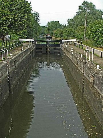
Dobbs Weir Lock facts for kids

Looking north
|
|
| Waterway | River Lee Navigation |
|---|---|
| County | Hertfordshire Essex |
| Maintained by | British Waterways |
| Operation | Manual |
| Length | 85 feet (25.9 m) |
| Width | 16 feet (4.9 m) |
| Fall | 5 feet 1 inch (1.5 m) |
| Distance to Bow Creek |
18.3 miles (29.5 km) |
| Distance to Hertford Castle Weir |
8.0 miles (12.9 km) |
| Coordinates | 51°45′09″N 0°00′12″E / 51.752395°N 0.003307°E |
Dobbs Weir Lock (also known as Lock Number 6) is a special kind of water elevator for boats. It is located on the River Lee Navigation near the town of Hoddesdon. This lock helps boats travel smoothly along the river, connecting different water levels. It is an important part of the waterway system that runs through Hertfordshire and Essex.
Contents
What is Dobbs Weir Lock?
A lock is like a watery lift for boats. It helps them move between different water levels on a river or canal. Imagine a boat needing to go uphill or downhill on the water. A lock makes this possible!
How Does a Lock Work?
When a boat wants to pass through, it enters a special chamber. Large gates then close behind it. Water is either added to the chamber to raise the boat, or removed to lower it. Once the boat is at the new water level, the gates at the other end open, and the boat can continue its journey. Dobbs Weir Lock is operated manually, meaning people have to open and close the gates themselves.
Key Facts About Dobbs Weir Lock
Dobbs Weir Lock is about 26 meters (85 feet) long. It is also about 4.8 meters (16 feet) wide. The water level changes by about 1.5 meters (5 feet, 1 inch) when a boat passes through. This lock is maintained by British Waterways, which looks after many canals and rivers in the UK.
Where is Dobbs Weir Lock Located?
Dobbs Weir Lock is found just south of a place called Dobbs Weir. It is also very close to where the Lynch Brook meets the Old River Lea. This area is quite scenic and interesting.
Nearby Natural Features
To the east of the lock, you'll find the Nazeing Mead complex of lakes. These lakes are beautiful and include a part of the Lee Flood Relief Channel. This channel helps manage water levels and prevent flooding in the area. The lock's location makes it a great spot to see different waterways coming together.
How to Visit Dobbs Weir Lock
Dobbs Weir Lock is a popular spot for people who enjoy being outdoors. There are several ways to get there and explore the area.
Getting There by Car
You can drive to Dobbs Weir Lock using Meadgate Road. This road leads from Carthagena Lock directly to the area around Dobbs Weir Lock. There might be limited parking, so it's good to check before you go.
Walking and Cycling Paths
If you enjoy walking or cycling, you're in luck! The lock is right on the towpath. This path is part of the famous Lea Valley Walk. The Lea Valley Walk is a long trail that follows the River Lea, offering beautiful views and a chance to see wildlife. It's a great way to explore the area on foot or by bike.
Public Transport Options
For those using public transport, the nearest train station is Broxbourne railway station. From there, you might need to walk or cycle a bit to reach the lock. It's always a good idea to plan your route ahead of time.

