Donnelly Dome facts for kids
Quick facts for kids Donnelly Dome |
|
|---|---|

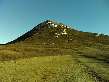
Donnelly Dome, AK, 2010
|
|
| Highest point | |
| Elevation | 1,168 m (3,832 ft) |
| Prominence | 2,400 ft (730 m) |
| Geography | |
| Geology | |
| Formed by | Glaciation |
Donnelly Dome is a cool mountain peak in Alaska. It's located west of the Richardson Highway. This highway is about 18 miles south of Delta Junction, Alaska. The mountain got its name in the 1920s. It was named after a nearby telegraph station called Donnelly, Alaska. Before that, people called it "Delta Dome." This was because it was close to the Delta River.
Discover Donnelly Dome
Donnelly Dome is a well-known summit in the Alaskan landscape. It stands tall at 3,832 feet (1,168 meters) above sea level. This makes it a noticeable landmark in the area. Its unique shape comes from ancient ice.
How Donnelly Dome Was Formed
Donnelly Dome was shaped by powerful glaciers. This happened between 70,000 and 100,000 years ago. During that time, huge sheets of ice covered the land. The mountain was completely hidden under these glaciers. Scientists call a mountain covered in ice a "fleigberg." The ice carved its sides, giving it its distinct dome shape.
Visiting Donnelly Dome
The land around Donnelly Dome is special. It is owned by the United States Army. This area is part of the Donnelly Training Area. It belongs to Fort Wainwright. Because of this, if you want to hike or visit, you need permission. Hikers must register for a Recreation Access Permit before they go. This helps keep everyone safe.


