
Dooley's Ferry Fortifications Historic District facts for kids
Quick facts for kids |
|
|
Dooley's Ferry Fortifications Historic District
|
|

Cemetery with earthworks
|
|

Location in Arkansas

Location in the United States
|
|
| Nearest city | Spring Hill |
|---|---|
| Area | 24 acres (9.7 ha) |
| NRHP reference No. | 04001031 |
| Added to NRHP | September 22, 2004 |
The Dooley's Ferry Fortifications Historic District is a special place in southwestern Arkansas. It holds old military dirt walls built during the American Civil War. These defenses were made in late 1864 by soldiers from the Confederate Army. They were ordered by Major-General John B. Magruder. The goal was to protect against possible attacks from the Union Army heading towards Shreveport, Louisiana.
These fortifications were placed in a very important spot. It was near Dooley's Ferry, which was a key crossing point on the Red River. After the war, a cemetery for African-Americans, called Dooley Hill Cemetery, was started right next to one of these old gun positions.
The Dooley's Ferry Fortifications were added to the National Register of Historic Places in 2004. This means they are recognized as important historical sites.
Contents
What Are Fortifications?
Fortifications are military defenses. They are often built to protect an area from attack. The ones at Dooley's Ferry are "earthworks." This means they are walls or mounds made from dirt. Soldiers would dig trenches and pile up earth to create strong barriers. These barriers could protect soldiers and cannons.
Why Were They Built?
These fortifications were built during the American Civil War (1861-1865). This war was fought between the northern states (the Union) and the southern states (the Confederacy). The Confederate Army built these defenses in late 1864. They were worried that Union forces might try to move towards Shreveport, Louisiana. Shreveport was an important city for the Confederacy.
Who Ordered the Forts?
Major-General John B. Magruder was a leader in the Confederate Army. He gave the orders to build these defenses. His plan was to stop any Union Army movements along the Red River.
Where Were They Located?
The fortifications were placed near Dooley's Ferry. This ferry was a very important way to cross the Red River. It was also near a major road intersection. Controlling this spot was key for moving troops and supplies. It also helped to block enemy movements.
Dooley Hill Cemetery
After the Civil War ended, a cemetery was started near one of the old gun positions. This cemetery is known as Dooley Hill Cemetery. It was created for African-Americans in the area. It stands as a reminder of the history of the land after the war.
Recognized History
The Dooley's Ferry Fortifications were officially recognized in 2004. They were added to the National Register of Historic Places. This list includes places across the United States that are important to history. Being on this list helps protect these sites. It also makes sure their stories are remembered for future generations.
Gallery
-
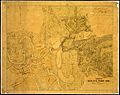
Map of the area around Dooley's Ferry, from the Civil War time (around 1861–1865).
-
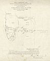
A survey map of Dooley's Ferry from 1900.


