Doumer Island facts for kids

Image of Doumer Island
|
|
|
Location in Antarctica
|
|
| Geography | |
|---|---|
| Location | Antarctica |
| Coordinates | 64°51′S 63°35′W / 64.850°S 63.583°W |
| Archipelago | Palmer Archipelago |
| Length | 8.3 km (5.16 mi) |
| Width | 3.7 km (2.3 mi) |
| Highest elevation | 515 m (1,690 ft) |
| Highest point | Doumer Hill |
| Administration | |
| Administered under the Antarctic Treaty System | |
| Demographics | |
| Population | Uninhabited |
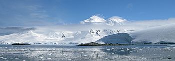
Doumer Island is a cool island in Antarctica, about 8.3 kilometers (5.2 miles) long and 3.7 kilometers (2.3 miles) wide. It's known for its tall, snow-covered peak that looks like a pyramid, reaching 515 meters (1,690 feet) high! This island is located between two other islands, Anvers Island and Wiencke Island, in a group called the Palmer Archipelago.
Discovering Doumer Island
Doumer Island was first spotted by the Belgian Antarctic Expedition way back in 1897-1899, led by a person named Adrien de Gerlache.
Later, in 1903-1905, another group called the French Antarctic Expedition, led by Jean-Baptiste Charcot, saw the island again and made detailed maps of it. They decided to name it after Paul Doumer. He was an important person in France, serving as the head of the French Chamber of Deputies and later even becoming the President of France.
Yelcho Research Station
On the southern side of Doumer Island, in a place called South Bay, there's a special research station. It's called the Yelcho Station. This station is run by the Chilean Antarctic Institute.
Scientists use Yelcho Station during the summer months to study the unique environment and wildlife of Antarctica. It's a place where important research happens to help us understand our planet better.
See also
 In Spanish: Isla Doumer para niños
 | William Lucy |
 | Charles Hayes |
 | Cleveland Robinson |


