
Wiencke Island facts for kids

Luigi peak, Fief Range, Wiencke Island
|
|

Wiencke Island
Location in Antarctica
Location in Antarctica
|
|
| Geography | |
|---|---|
| Location | Antarctica |
| Coordinates | 64°50′S 63°23′W / 64.833°S 63.383°W |
| Archipelago | Palmer Archipelago |
| Area | 67 km2 (26 sq mi) |
| Length | 26 km (16.2 mi) |
| Width | 5.6 km (3.48 mi) |
| Highest elevation | 1,435 m (4,708 ft) |
| Highest point | Luigi Peak |
| Administration | |
| Administered under the Antarctic Treaty System | |
| Demographics | |
| Population | Uninhabited |
Wiencke Island is an island about 26 kilometers (16 miles) long and 3 to 8 kilometers (1.9 to 5.0 miles) wide. It covers an area of about 67 square kilometers (26 square miles). This island is the most southern of the main islands in the Palmer Archipelago. It's located between Anvers Island to the north (across the Neumayer Channel) and the west coast of the Antarctic Peninsula to the east (across the Gerlache Strait).
Contents
What is Wiencke Island Like?

Wiencke Island is mostly covered by thick glaciers, snow, and ice. It's a very rocky place. You can find some small rocky beaches on the western and northern parts of the island. In these areas, you might see some grasses, moss, and lichens growing.
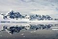
The island has three main mountain ridges. In the northwest, there is Nemo Peak, which is 864 meters (2,835 feet) high. To the northeast, you'll find Nipple Peak. The highest point is Luigi Peak, in the southwest, standing at 1,415 meters (4,642 feet). Luigi Peak is the island's highest mountain, even though it hasn't been fully measured yet.
Important Points and Nearby Islands
The very northern tip of Wiencke Island is called Cape Astrup. It's a tall, dark cliff that was found by the Belgian Antarctic Expedition (1897–99). It was named after Eivind Astrup, a Norwegian explorer.
The very southeast end of the island is called Principal Point. This is a noticeable, ice-covered piece of land. It was first mapped by the French Antarctic Expedition (1903–05). The name "Principal Point" was given by an Argentine expedition in 1953–54 because it's such a prominent feature. Close by, on the southeast coast, is Pursuit Point, which is an important area for birds.
Wiencke Island is surrounded by several smaller islands. For example, Breakwater Island is 33 meters (108 feet) high and located 8 kilometers (5.0 miles) north of Cape Astrup. Near the southeast side, there is Fridtjof Island, which is 136 meters (446 feet) high. It's connected to Wiencke by a line of small rocks and tiny islands. Near Cape Willems, the most southeastern point of Wiencke, are the Bob Islands. These three islands are volcanic and can be up to 134 meters (440 feet) high.
History of Wiencke Island
Early Discoveries
It seems that Edward Bransfield first saw Wiencke Island in January 1820 while on the ship Williams. He thought it was a cape. In 1829, Henry Foster sailed around the island. The first person to actually land on the island was the German explorer Eduard Dallmann in 1873. He described it as a "lonely place."
The island got its name from the Belgian Antarctic Expedition (1897–99), led by Adrien de Gerlache. They named it after Carl August Wiencke, a Norwegian sailor who sadly fell overboard and died during their journey.
20th Century Activities
During World War II, Britain set up bases in Antarctica. In 1944, they established a base in a bay on Wiencke Island, and another on Deception Island. A third base was set up at Hope Bay in 1945. These bases were used to report weather and to check for any German naval activity. Today, only one of these original bases remains. It's located on Goudier Island in the bay of Port Lockroy, near Wiencke Island's southwestern end.
In 1947, Argentina installed a light tower at Py Point on nearby Doumer Island. Later, in 1957, a small shelter was built in Dorian Bay, north of Port Lockroy. The British Antarctic Survey (BAS) built another hut, called the Damoy Point refuge, near this Argentine shelter in 1975. This hut was used as a base for a temporary summer airstrip on the ice. It was no longer used after 1995 and has now been restored as a historic site.
Another science station, called Yelcho, was set up in 1962 by the Chilean Navy. It was located in South Bay on nearby Doumer Island. In 1957, an emergency shelter was built in Alice Creek, close to Goudier Island. Two years later, a larger hut was added. These huts were used for maintaining special equipment. Both huts were removed in 1996 when they were no longer needed, and Base 'A' on Goudier Island was restored.
Island Features
- Comer Range
- Jabet Peak
- Noble Peak
- Dayné Peak
Images for kids
-
Luigi peak, Fief Range, Wiencke Island
See also
 In Spanish: Isla Wiencke para niños
