Dover, Illinois facts for kids
Quick facts for kids
Dover, Illinois
|
|
|---|---|

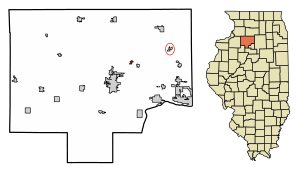
Location of Dover in Bureau County, Illinois.
|
|

Location of Illinois in the United States
|
|
| Country | United States |
| State | Illinois |
| County | Bureau |
| Townships | Dover, Berlin |
| Area | |
| • Total | 0.29 sq mi (0.8 km2) |
| • Land | 0.28 sq mi (0.7 km2) |
| • Water | 0.00 sq mi (0 km2) 0% |
| Elevation | 741 ft (226 m) |
| Population
(2020)
|
|
| • Total | 135 |
| • Density | 466/sq mi (180/km2) |
| Time zone | UTC-6 (CST) |
| • Summer (DST) | UTC-5 (CDT) |
| ZIP Code(s) |
61323
|
| Area codes | 815 & 779 |
| FIPS code | 17-20526 |
| GNIS ID | 2398743 |
| Wikimedia Commons | Dover, Illinois |
Dover is a small village located in Bureau County, Illinois, in the United States. In 2020, about 135 people lived there. It's part of the wider Ottawa area, which is a group of towns and cities connected by their economy.
Contents
Dover's History
Dover was officially planned and settled in 1833. It was named after Dover, New Hampshire, because one of the first people to settle here came from that city. A post office has been open in Dover since 1839, helping people send and receive mail for a very long time.
A notable person from Dover was Joseph R. Peterson (1904–1967). He was an Illinois lawyer and a state legislator. He even served as the mayor of Dover in 1929 and 1930.
Where is Dover Located?
Dover is found at these coordinates: 41°26′7″N 89°23′45″W / 41.43528°N 89.39583°W. This means it's located at 41.435327 degrees North latitude and -89.395830 degrees West longitude.
The village is quite small, covering about 0.28 square miles (which is about 0.73 square kilometers) of land. There is no water area within the village limits.
Who Lives in Dover?
| Historical population | |||
|---|---|---|---|
| Census | Pop. | %± | |
| 1850 | 103 | — | |
| 1860 | 362 | 251.5% | |
| 1870 | 304 | −16.0% | |
| 1880 | 239 | −21.4% | |
| 1890 | 220 | −7.9% | |
| 1900 | 247 | 12.3% | |
| 1910 | 181 | −26.7% | |
| 1920 | 165 | −8.8% | |
| 1930 | 155 | −6.1% | |
| 1940 | 155 | 0.0% | |
| 1950 | 191 | 23.2% | |
| 1960 | 171 | −10.5% | |
| 1970 | 176 | 2.9% | |
| 1980 | 213 | 21.0% | |
| 1990 | 163 | −23.5% | |
| 2000 | 172 | 5.5% | |
| 2010 | 168 | −2.3% | |
| 2020 | 135 | −19.6% | |
| U.S. Decennial Census | |||
According to the 2020 census, 135 people lived in Dover. There were 62 households and 46 families. This means there were about 482 people per square mile.
Most of the people in Dover (about 94.81%) were White. A small number were Native American (0.74%), or from other races (2.22%), or a mix of two or more races (2.22%). About 5.19% of the population identified as Hispanic or Latino.
Households and Families
Out of the 62 households, about 27.4% had children under 18 living with them. Most households (72.58%) were married couples living together. About 22.58% of all households were made up of people living alone. Of those living alone, 12.90% were 65 years old or older. The average household had about 2.63 people.
Age and Income
The people in Dover have a wide range of ages. About 20.6% were under 18 years old. About 31.2% were 65 years old or older. The average age in the village was 55.2 years.
The average income for a household in Dover was $36,618. For individuals, the average income was $29,457. About 13.0% of families and 17.0% of all people in Dover lived below the poverty line. This included 20.7% of those under 18 and 18.2% of those 65 or older.
See also

- In Spanish: Dover (Illinois) para niños

