Downes Glacier facts for kids
Quick facts for kids Downes Glacier |
|
|---|---|

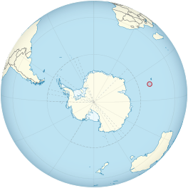
Location of Heard Island and McDonald Islands on the globe
|
|
| Type | tidewater |
| Location | Heard Island Territory of Heard Island and McDonald Islands Australia |
| Coordinates | 53°2′S 73°31′E / 53.033°S 73.517°E |
| Thickness | approximately 55 meters |
| Terminus | Mechanics Bay, between Saddle Point and Cape Bidlingmaier |
| Status | Retreating |
Downes Glacier is a large tidewater glacier found on the north side of Heard Island. This island is located in the southern Indian Ocean. A tidewater glacier is a special type of glacier that flows all the way into the ocean.
The glacier flows north towards the coast of Heard Island. It passes on both sides of a place called Cape Bidlingmaier. The end of a glacier is called its terminus. Downes Glacier's terminus is in Mechanics Bay.
To the east of Downes Glacier, you'll find Ealey Glacier. Its terminus is very close to Cape Bidlingmaier. To the west, there is Challenger Glacier. Its terminus is near Corinthian Bay. A spot called Saddle Point separates Downes Glacier from Challenger Glacier.
Discovering and Naming Downes Glacier
Scientists first explored and mapped Downes Glacier in 1948. This was done by a group called ANARE. ANARE stands for the Australian National Antarctic Research Expeditions. They explore and study the Antarctic region.
The glacier was later named by the Antarctic Names Committee of Australia (ANCA). They named it after M.C. Downes. He was a biologist who worked for ANARE. M.C. Downes studied the wildlife on Heard Island in 1951 and again in 1963.
- You can click here to see a map of Heard Island and McDonald Islands. This map shows all the main features.
![]() This article incorporates public domain material from the United States Geological Survey document "Downes Glacier" (content from the Geographic Names Information System). Lua error in Module:EditAtWikidata at line 29: attempt to index field 'wikibase' (a nil value).
This article incorporates public domain material from the United States Geological Survey document "Downes Glacier" (content from the Geographic Names Information System). Lua error in Module:EditAtWikidata at line 29: attempt to index field 'wikibase' (a nil value).
 | James Van Der Zee |
 | Alma Thomas |
 | Ellis Wilson |
 | Margaret Taylor-Burroughs |

