Dripping Springs, Arizona facts for kids
Quick facts for kids
Dripping Springs, Arizona
|
|
|---|---|

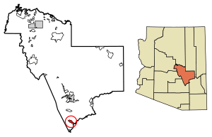
Location of Dripping Springs in Gila County, Arizona.
|
|
| Country | United States |
| State | Arizona |
| County | Gila |
| Area | |
| • Total | 6.73 sq mi (17.43 km2) |
| • Land | 6.73 sq mi (17.43 km2) |
| • Water | 0.00 sq mi (0.00 km2) |
| Elevation | 2,241 ft (683 m) |
| Population
(2020)
|
|
| • Total | 142 |
| • Density | 21.10/sq mi (8.15/km2) |
| Time zone | UTC-7 (Mountain (MST)) |
| ZIP code |
85192
|
| Area code(s) | 928 |
| GNIS feature ID | 2582775 |
Dripping Springs is a small community in Gila County, Arizona, in the United States. It is called a census-designated place because the government counts its population for official records.
Dripping Springs is about 14 miles north of the town of Hayden. You can find it along Arizona State Route 77. In 2020, about 142 people lived there.
Where is Dripping Springs?
Dripping Springs is located in a specific spot on Earth. Its exact coordinates are 33.104954 degrees North and 110.755088 degrees West.
The U.S. Census Bureau says that the community covers an area of about 6.7 square miles (17.43 square kilometers). All of this area is land, with no water.
How many people live there?
The word "demographics" means facts about a group of people. This includes things like how many people live somewhere.
The population of Dripping Springs has changed over time:
| Historical population | |||
|---|---|---|---|
| Census | Pop. | %± | |
| 2020 | 142 | — | |
| U.S. Decennial Census | |||
See also
 In Spanish: Dripping Springs (Arizona) para niños
 | Frances Mary Albrier |
 | Whitney Young |
 | Muhammad Ali |


