Drummond, Montana facts for kids
Quick facts for kids
Drummond, Montana
|
|
|---|---|

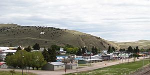
Drummond, June 2012
|
|

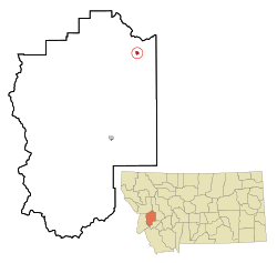
Location of Drummond, Montana
|
|
| Country | United States |
| State | Montana |
| County | Granite |
| Area | |
| • Total | 0.54 sq mi (1.40 km2) |
| • Land | 0.54 sq mi (1.40 km2) |
| • Water | 0.00 sq mi (0.00 km2) |
| Elevation | 3,954 ft (1,205 m) |
| Population
(2020)
|
|
| • Total | 272 |
| • Density | 501.85/sq mi (193.78/km2) |
| Time zone | UTC-7 (Mountain (MST)) |
| • Summer (DST) | UTC-6 (MDT) |
| ZIP code |
59832
|
| Area code(s) | 406 |
| FIPS code | 30-21850 |
| GNIS feature ID | 2412449 |
Drummond is a small town located in Granite County, Montana, in the United States. In 2020, about 272 people lived there.
Contents
Where is Drummond, Montana?
Drummond is easy to reach from Interstate 90, using exits 153 and 154. The town is located just north of the Clark Fork River.
According to the United States Census Bureau, Drummond covers about 0.53 square miles (1.37 km2) of land. This means it's a fairly small town in terms of its area.
What is Drummond's Climate Like?
Drummond has a type of weather called a semi-arid climate. This means it's generally dry, but not a desert. It gets some rain, but not a lot. On climate maps, this is shown as "BSk".
Here's a quick look at the average weather in Drummond:
| Climate data for Drummond, Montana | |||||||||||||
|---|---|---|---|---|---|---|---|---|---|---|---|---|---|
| Month | Jan | Feb | Mar | Apr | May | Jun | Jul | Aug | Sep | Oct | Nov | Dec | Year |
| Mean daily maximum °F (°C) | 28 (−2) |
32 (0) |
36 (2) |
45 (7) |
54 (12) |
63 (17) |
75 (24) |
73 (23) |
61 (16) |
50 (10) |
37 (3) |
31 (−1) |
49 (9) |
| Mean daily minimum °F (°C) | 10 (−12) |
12 (−11) |
12 (−11) |
21 (−6) |
28 (−2) |
36 (2) |
42 (6) |
40 (4) |
33 (1) |
27 (−3) |
18 (−8) |
13 (−11) |
24 (−4) |
| Average precipitation inches (mm) | 2.5 (64) |
2.3 (58) |
2.4 (61) |
2.5 (64) |
3.1 (79) |
3.2 (81) |
1.4 (36) |
1.4 (36) |
1.6 (41) |
1.5 (38) |
2.1 (53) |
2.5 (64) |
26.4 (670) |
| Source: Weatherbase | |||||||||||||
A Brief History of Drummond
How Drummond Got Its Name
The Northern Pacific Railroad arrived in the area in 1883. Before that, the town was called Edwardsville. The railroad changed the name to Drummond. It was named either after an engineer who worked for the Northern Pacific Railroad or after a local trapper named Hugh Drummond.
Long-Serving Mayor Gail Leeper
One notable person in Drummond's history is Mayor Gail Leeper. She was first elected as mayor in 1993. She served for many years, even seeking her seventh term in 2017. This shows how dedicated she was to her town.
Who Lives in Drummond?
The number of people living in Drummond has changed over the years. Here's how the population has looked:
| Historical population | |||
|---|---|---|---|
| Census | Pop. | %± | |
| 1950 | 531 | — | |
| 1960 | 577 | 8.7% | |
| 1970 | 494 | −14.4% | |
| 1980 | 414 | −16.2% | |
| 1990 | 264 | −36.2% | |
| 2000 | 318 | 20.5% | |
| 2010 | 309 | −2.8% | |
| 2020 | 272 | −12.0% | |
| U.S. Decennial Census | |||
Drummond's Population in 2010
According to the census taken in 2010, there were 309 people living in Drummond. These people lived in 143 different homes, and 84 of those were families.
- Population Density: There were about 583 people living per square mile (225 people per square kilometer).
- Housing: There were 179 housing units, like houses or apartments.
- Backgrounds: Most people (97.7%) were White. A small number were African American (0.3%), Native American (0.3%), or from two or more backgrounds (1.6%). About 1.6% of the population identified as Hispanic or Latino.
Homes and Families
Out of the 143 homes:
- 21.7% had children under 18 living there.
- 47.6% were married couples living together.
- 7.0% had a female head of the household with no husband present.
- 4.2% had a male head of the household with no wife present.
- 41.3% were not families (meaning people living alone or with roommates).
On average, about 2.11 people lived in each home, and about 2.80 people lived in each family household.
Age Groups in Drummond
The average age of people in Drummond in 2010 was 46.9 years old.
- 19.1% of residents were under 18 years old.
- 7.1% were between 18 and 24 years old.
- 18.5% were between 25 and 44 years old.
- 32% were between 45 and 64 years old.
- 23.3% were 65 years old or older.
In terms of gender, 48.5% of the population was male and 51.5% was female.
Education in Drummond
The schools in Drummond are managed by Drummond Public Schools. The local high school is Drummond High School, and their sports teams are called the Trojans.
The town also has a library, the Drummond School and Community Library, which serves both students and the wider community.
See also
 In Spanish: Drummond (Montana) para niños
 | Jackie Robinson |
 | Jack Johnson |
 | Althea Gibson |
 | Arthur Ashe |
 | Muhammad Ali |

