Drury, Missouri facts for kids
Quick facts for kids
Drury, Missouri
|
|
|---|---|
|
Community
|
|
| Country | U. S. A. |
| State | Missouri |
| County | Douglas County |
| Elevation | 368 m (1,207 ft) |
| Time zone | UTC-6 (CST) |
| • Summer (DST) | UTC-5 (CDT) |
| Zip Code |
65638 (historical)
|
| GNIS feature ID | 749698 |
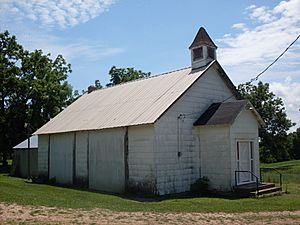
Drury is a small, quiet community in Douglas County, Missouri, United States. It is known as an unincorporated community. This means it's a group of homes and buildings that doesn't have its own local government like a city or town. You can find Drury about fifteen miles south of Mountain Grove. It is also about three miles south of Vanzant, right on Route 95.
Contents
Discovering Drury, Missouri
Drury is a peaceful spot in the countryside of southern Missouri. It's a place where people live without a formal town council or mayor. Instead, it's part of the larger Douglas County.
Where is Drury Located?
Drury sits on a ridge, which is like a long, narrow hilltop. This ridge is about 1,207 feet above sea level. Small streams flow from this ridge into Bryant Creek. These streams help shape the beautiful landscape around Drury.
A Look at Drury's Past
Drury has a bit of history, even though it's a small community.
How Drury Got Its Name
The community of Drury was named after a local family. The Drury family lived in the area and were important to its early development. Many places get their names from the first families who settled there.
The Old Post Office
For over 100 years, Drury had its own post office. It opened in 1893 and served the community until 2003. During that time, people in Drury used the zip code 65638 for their mail. The post office was a central part of life for the residents.
 | Leon Lynch |
 | Milton P. Webster |
 | Ferdinand Smith |


