
Mountain Grove, Missouri facts for kids
Quick facts for kids
Mountain Grove, Missouri
|
|
|---|---|
| City of Mountain Grove | |

Union Street
|
|

Location of Mountain Grove, Missouri
|
|
| Country | United States |
| State | Missouri |
| Counties | Wright, Texas |
| Area | |
| • Total | 4.05 sq mi (10.48 km2) |
| • Land | 4.01 sq mi (10.40 km2) |
| • Water | 0.03 sq mi (0.08 km2) |
| Elevation | 1,483 ft (452 m) |
| Population
(2020)
|
|
| • Total | 4,313 |
| • Density | 1,074.22/sq mi (414.78/km2) |
| Time zone | UTC-6 (Central (CST)) |
| • Summer (DST) | UTC-5 (CDT) |
| ZIP code |
65711
|
| Area code(s) | 417 |
| FIPS code | 29-50402 |
| GNIS feature ID | 2395132 |
Mountain Grove is a city located in the state of Missouri, USA. It is found in both Wright County and Texas County. The city is nestled within the Ozarks, a beautiful highland area in the south-central part of Missouri. In 2020, about 4,313 people lived here.
Contents
History of Mountain Grove
The area where Mountain Grove now stands has been settled for a long time. A post office called Mountain Grove has been open since 1875. The city gets its name from a group of trees on a high piece of land where the town first began.
Early Settlements and Names
Back in 1841, a small community was built east of Mountain Grove. It was near a spring and a grove of hickory trees. This early settlement was first called Hickory Spring. It even had a post office starting in 1851, but this office closed in 1861.
Civil War Skirmish
During the American Civil War, a small fight, called a skirmish, happened in the town. This event took place on March 9, 1862.
How Mountain Grove Got Its Name
Later, a new post office was opened and named after Judge Robert W. Fyan. He was an important person in the county's early days. In 1859, a general store was built about a mile west of Hickory Spring. This store was at a crossroads.
The Fyan post office changed its name to Mountain Grove in 1878. This new name referred to its location on a ridge, or high area, surrounded by a grove of trees. People called it the "mountain store" or "the mountain" because it was about 1,525 feet high.
Town Growth and Changes
A famous event happened in May 1883. A "nipping frost" (a very cold spell) caused many trees and shrubs to be cut down as if by an axe. This event helped join Mountain Grove and the nearby Fyan area. In June, the Fyan depot (a train station) was also renamed Mountain Grove.
The town officially applied for a new charter in 1886. It changed its borders and held its first election.
Historic Buildings
Several buildings in or near Mountain Grove are listed on the National Register of Historic Places. This means they are important historical sites. These include the Administration Building, Missouri State Fruit Experiment Station, the Mountain Grove Bandstand, and the Mountain Grove City Hall.
Geography and Location
Mountain Grove is located in the Ozarks region of Missouri. It sits along the southern edge of the Salem Plateau, which is a part of the Ozarks. The city is served by major roads like US Route 60 and Missouri Route 95.
Most of Mountain Grove is in Wright County, Missouri. However, the eastern part of the city reaches into Texas County, Missouri. The city is on a drainage divide. This means that rain falling on one side flows south towards the White River. Rain falling on the other side flows north towards the Missouri River.
The city covers a total area of about 4.04 square miles (10.48 square kilometers). Most of this area, about 4.01 square miles (10.40 square kilometers), is land. A small part, about 0.03 square miles (0.08 square kilometers), is water.
Population and People
| Historical population | |||
|---|---|---|---|
| Census | Pop. | %± | |
| 1880 | 92 | — | |
| 1890 | 830 | 802.2% | |
| 1900 | 1,004 | 21.0% | |
| 1910 | 1,722 | 71.5% | |
| 1920 | 2,212 | 28.5% | |
| 1930 | 2,229 | 0.8% | |
| 1940 | 2,431 | 9.1% | |
| 1950 | 3,106 | 27.8% | |
| 1960 | 3,176 | 2.3% | |
| 1970 | 3,377 | 6.3% | |
| 1980 | 3,974 | 17.7% | |
| 1990 | 4,182 | 5.2% | |
| 2000 | 4,574 | 9.4% | |
| 2010 | 4,789 | 4.7% | |
| 2020 | 4,313 | −9.9% | |
| U.S. Decennial Census | |||
Population in 2010
In 2010, the city had 4,789 people living there. There were 2,008 households, which are groups of people living together. About 1,217 of these were families. The city had about 1,194 people per square mile.
Many types of households lived in Mountain Grove. About 32.3% of households had children under 18. Around 40.8% were married couples living together. About 34.4% of all households were made up of single individuals.
The average age of people in the city was 37.7 years old. About 26.7% of residents were under 18. About 19.1% were 65 years old or older. The population was 46.3% male and 53.7% female.
Education in Mountain Grove
Mountain Grove has a good school system for its students.
Public Schools
The city's public schools are part of the Mountain Grove R-III School District. They are a "class 3A" school district in Missouri. The district includes an elementary school for grades Pre-K through 4th. There is also a middle school for grades 5th through 8th. Finally, there is a high school for grades 9th through 12th.
Mountain Grove High School also has the Ozark Mountain Technical Center. This center helps students learn technology skills. These skills are useful for different job paths after high school.
Private Schools
Mountain Grove Christian Academy is a private school in the city. It has about 68 students. The academy teaches students from Pre-K all the way up to 12th grade.
Higher Education and Research
Missouri State University has a special place in Mountain Grove. It runs the Missouri State Fruit Experiment Station. This station is a large area of about 190 acres (0.77 square kilometers). It focuses on studying fruits.
The station includes the Center for Grapevine Biotechnology. It also has the Mountain Grove Cellars. This station is mainly connected to the university's Plant Science master's degree program.
Public Library
Mountain Grove also has a public library. It is a branch of the Wright County Library system. Libraries are great places to read, learn, and explore new ideas.
Notable People from Mountain Grove
Many interesting people have connections to Mountain Grove.
- Russ Dugger (born 1975) is a stock car racing driver.
- Don Faurot (1902–1995) was born in Mountain Grove. He was a famous head coach for the University of Missouri football team. He was also a longtime athletic director.
- Hooks Iott (1919-1980) was a Major League Baseball player. He played for the St. Louis Browns and New York Giants in the 1940s.
- Paul McDonald Robinett (1893–1975) was born in Mountain Grove. He became a Brigadier General in the U.S. Army. He is also buried there.
Images for kids
-
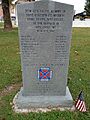
The front of the memorial dedicated to the Confederate soldiers who died in the Mountain Grove Skirmish in the American Civil War
-
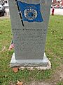
The back of the memorial dedicated to the Confederate soldiers who died in the Mountain Grove Skirmish in the American Civil War


See also
 In Spanish: Mountain Grove (Misuri) para niños
