
Dunham Run (Pine Creek tributary) facts for kids
Quick facts for kids Dunham Run |
|
|---|---|


|
|
| Other name(s) | Tributary to Pine Creek |
| Country | United States |
| State | Pennsylvania |
| County | Warren |
| Physical characteristics | |
| Main source | divide between Gilson Run and West Hickory Creek about 0.5 miles northeast of Pineville, Pennsylvania 1,625 ft (495 m) 41°40′06″N 079°33′51″W / 41.66833°N 79.56417°W |
| River mouth | Pine Creek about 2 miles east of Dotyville, Pennsylvania 1,225 ft (373 m) 41°37′44″N 079°35′23″W / 41.62889°N 79.58972°W |
| Length | 3.32 mi (5.34 km) |
| Basin features | |
| Progression | generally south |
| River system | Allegheny River (Oil Creek) |
| Basin size | 3.34 square miles (8.7 km2) |
| Tributaries |
|
Dunham Run is a small stream, about 3.32 mi (5.34 km) long, located in Warren County, Pennsylvania. It's like a smaller helper stream that flows into a bigger one called Pine Creek.
Contents
Where Does Dunham Run Flow?
Dunham Run starts its journey in Warren County, Pennsylvania. It begins about 2 miles east of a place called Dotyville. From there, it flows generally south. Its journey ends when it joins Pine Creek. This meeting point is about 0.5 miles west of Enterprise, Pennsylvania.
What is the Dunham Run Area Like?
The area that Dunham Run drains is called its watershed. This watershed covers about 3.34 square miles (8.7 km2) of land. Imagine a big bowl where all the rainwater eventually flows into Dunham Run.
Rainfall and Forests
This area gets a good amount of rain each year. On average, it receives about 44.8 inches of precipitation. A large part of the Dunham Run watershed is covered by forests. About 92% of the land here is forested. This means there are lots of trees! Forests are important for keeping the water clean and providing homes for wildlife.
Images for kids
-
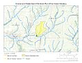
This map shows where Dunham Run flows and its watershed in Crawford County, Pennsylvania.
.jpg)
