
Dunton Cove facts for kids
Quick facts for kids Dunton Cove |
|
|---|---|
| The Covenanters' Cave | |

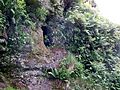
The entrance into Dunton Cove Covenanters Cave.
|
|
| Location | Waterside, East Ayrshire |
| OS grid | NS 509 448 |
| Length | 10 feet (3.0 m) |
| Elevation | 20 feet (6.1 m) |
| Entrances | 1 |
| Difficulty | Challenging |
| Hazards | Access |
| Access | By hand and foot holds |
Dunton Cove, also known as the Covenanters' Cave, is a special cave in East Ayrshire, Scotland. It's not a natural cave, but one made by people. You can find it in a rocky cliff overlooking the Craufurdland Water, near the village of Waterside.
This cave was a secret hiding spot for a group of Scottish people called the Covenanters. They used it in the 1600s, especially during a difficult time in the 1680s.
Exploring Dunton Cove

Dunton Cove is located in a stone cliff. It sits above the Craufurdland Water. You can find it on the east side of the water. The cave is just off a private road. This road leads from Airtnoch Farm. It goes through forest areas.
The cave is quite small. Only a few people can fit inside. Its opening is shaped like a rectangle. This shape shows that people made it. It might have been an existing hole that was made bigger.
To get into the cave, you need to climb. There are hand and foot holds cut into the rock. But it's still a tricky climb. Inside, the cave is very simple. There are no special features. It doesn't even have a shelf to sit on. This suggests it was a short-term refuge. People likely used it only when soldiers were nearby.
The cave's opening is easy to see from the water. It's said that a bush, like gorse or willow, was used. People would pull it up and tie it over the entrance. This helped to hide the cave from view.
The Covenanters' Story
The word cove in Scots means 'cave'. This name tells us what the place is.

The cave was first written about in 1856. This was in an old map book called the 'Name Book'. Local people shared stories about it. They said Covenanters used it as a hiding place. They also confirmed it was man-made.
The Covenanters were a group of Scottish Presbyterians. They believed in their right to worship freely. They signed agreements, or "covenants," to protect their faith. During the 1600s, they faced hard times. The government tried to control their church. Many Covenanters were hunted down. They had to hide to stay safe.
People in this area strongly supported the Covenanters. Records from 1684 list some local Covenanters. These included Andrew Gemmil and James Lindsay. John Howie from Lochgoin Farm was also listed. These people often had to go into hiding.
There's a famous story about Dunton Cove. Soldiers were chasing Covenanters across the moors. The Covenanters reached the Craufurdland Water. They quickly hid inside this cave. The soldiers didn't want to get wet. So, they fired their guns into the cave opening. They thought they had killed the men. But the Covenanters had laid flat on the floor. They were safe and unharmed.
Dunton Cove wasn't the only hiding place. Other caves in Scotland were also used. For example, Cleeves Cove near Dalry was a refuge. Peden's Cave near Ochiltree was another. These caves helped Covenanters survive.
Images for kids
-
The entrance into Dunton Cove Covenanters Cave.
-
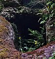
Rectangular entrance to the cave.
-
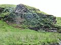
The cave within the cliff face.
