
Dyess, Arkansas facts for kids
Quick facts for kids
Dyess, Arkansas
|
|
|---|---|

Dyess Town Hall
|
|

Location in Mississippi County, Arkansas
|
|
| Country | United States |
| State | Arkansas |
| County | Mississippi |
| Area | |
| • Total | 0.96 sq mi (2.49 km2) |
| • Land | 0.96 sq mi (2.49 km2) |
| • Water | 0.00 sq mi (0.00 km2) |
| Elevation | 223 ft (68 m) |
| Population
(2020)
|
|
| • Total | 339 |
| • Density | 352.76/sq mi (136.25/km2) |
| Time zone | UTC-6 (Central (CST)) |
| • Summer (DST) | UTC-5 (CDT) |
| ZIP code |
72330
|
| Area code(s) | 870 |
| FIPS code | 05-20230 |
| GNIS feature ID | 2406409 |
Dyess is a small town in Mississippi County, Arkansas, United States. It was started in 1934 as the Dyess Colony. This was part of a big plan by President Franklin D. Roosevelt to help people during the Great Depression.
The Dyess Colony was the largest farming community ever created by the U.S. government to help people. It is also famous as the childhood home of the legendary country singer Johnny Cash. In 2020, about 339 people lived in Dyess.
-
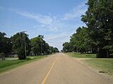
Main Street in Dyess
-
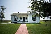
Farm No. 266 - boyhood home of Johnny Cash


Contents
History of Dyess
How Dyess Colony Started
The Dyess Colony was created in 1934. It was part of President Franklin D. Roosevelt's "New Deal" programs. These programs aimed to help people who were struggling during the Great Depression. This was a time when many people had no jobs or money.
The idea for the colony came from William Reynolds Dyess (1894–1936). He was a local politician and cotton farmer in Mississippi County. He wanted to create a self-supporting farm community for 800 families. These families would live and work on unused farmland in the Mississippi Delta.
Mr. Dyess presented his plan to Harry Hopkins, who led the Federal Emergency Relief Administration (FERA). Hopkins approved the project in March 1934.
About 15,144 acres (61.28 km2) of land were bought for the colony. This land was mostly swamp and cut-down forest. However, it had very rich soil from the Mississippi River. This area was known for growing a lot of cotton.

The plan was changed to include 500 families instead of 800. These families were chosen from sharecroppers and tenant farmers in Arkansas. To be chosen, a person had to be an experienced farmer who had lost everything. They also had to be in good health, under 50, and from Arkansas.
FERA provided the money to buy the land. At first, the Arkansas Emergency Relief Administration managed the project. Later, a new group called Dyess Colony Inc. took over. The U.S. Secretary of Agriculture held the company's stock.
The main goal was to give poor families a chance to own land and start fresh. Each family received a farm of 20 or 40 acres.
How the Colony Was Run
William Dyess and a board of directors carefully planned and managed the colony. They oversaw the daily activities of the people living there.
Sadly, on January 14, 1936, Mr. Dyess and his main finance director, Robert H. McNair Jr., died in a plane crash. They were flying back to Arkansas from Washington, D.C.
After Mr. Dyess's death, Floyd Sharp took over the leadership. He was a lawyer from Little Rock and a friend of Dyess. Lawrence Westbrook also helped lead the colony.
The colony had two main groups that worked together. One was a consumer cooperative that ran a store and other businesses for the residents. The other was a producer cooperative that helped process and sell the cotton grown by the farmers. By 1938, the colony also had its own cooperative credit union.
When the Colony Ended
The Dyess Colony faced problems from Governor Carl E. Bailey. He was a political rival of Floyd Sharp. The governor and his friends tried to weaken the colony.
On March 10, 1939, the Arkansas Corporation Commission canceled the colony's official status. They said it had not filed reports or paid a small annual fee for three years.
To save the colony, a new group was formed called the Dyess Rural Rehabilitation Corporation (DRRC). Dyess Colony Inc. sold its property to this new group. This helped the non-profit colony continue until 1944. At that time, the DRRC became part of the Farm Security Administration (FSA). The federal government officially ended its involvement in the project in 1951.
Geography
Dyess is located in the southwestern part of Mississippi County. It is about 19 miles (31 km) southwest of Osceola, which is the county seat.
The town covers a total area of 0.96 square miles (2.49 km2). All of this area is land.
Population Information
The population of Dyess has changed over the years:
- 1970: 433 people
- 1980: 446 people
- 1990: 466 people
- 2000: 515 people
- 2010: 410 people
- 2020: 339 people
In 2010, most people living in Dyess were White (83.2%). A small number were Black (1.2%) or from two or more races (2.0%). About 13.7% of the population was Hispanic or Latino.
In 2000, there were 515 people living in the town. The average household had about 2.91 people. The average family had about 3.36 people.
The population was quite young. About 31.5% of the people were under 18 years old. The median age was 29 years.
Education

Students in Dyess attend public schools run by the Rivercrest School District. This district used to be called the Southern Mississippi County School District. Students go to Rivercrest High School, which is near Wilson.
The original Dyess school district joined the South Mississippi district in 1968.
Famous People from Dyess
Dyess is well-known as the hometown of the famous country singer-songwriter Johnny Cash. He grew up here from the age of three. His childhood home, known as the Johnny Cash Boyhood Home, is a special historical site. Many other buildings from the colony period are also listed on the National Register of Historic Places.
See also
 In Spanish: Dyess (Arkansas) para niños
