Dísert Óengusa facts for kids
 |
|
| Monastery information | |
|---|---|
| Other names | Disert-aengusa, St Aengus's Hermitage, Dysert Aenghusa, Dysert Oenghusa, Desert Oenghus |
| Order | Culdees |
| Established | AD 780 |
| Diocese | Limerick |
| People | |
| Founder(s) | Óengus of Tallaght |
| Architecture | |
| Status | Inactive |
| Site | |
| Location | Carrigeen, Croom, County Limerick |
| Coordinates | 52°31′15″N 8°44′41″W / 52.520931°N 8.744713°W |
| Public access | Yes |
| Official name | Dísert Óengusa Early Medieval Hermitage |
| Reference no. | 83 |
Dísert Óengusa is an ancient place in County Limerick, Ireland. It was once a quiet hermitage, which is a special place where a religious person, like a monk, lives alone to pray and think. Today, it is a National Monument, meaning it's a very important historical site protected by the country.
Where is Dísert Óengusa?
You can find Dísert Óengusa about 1.8 kilometers (just over a mile) west of a town called Croom. It's located close to where the River Maigue begins.
A Look Back in Time: History of Dísert Óengusa
Dísert Óengusa was likely started around the year 780 AD by a person named Óengus of Tallaght. He was also known as Óengus the Culdee. The Culdees were a group of religious people in Ireland and Scotland during the Middle Ages. Óengus stayed at the hermitage for two years before moving on.
This monastery is mentioned in old records from the year 1033. Some of the oldest parts of the ruins you can see today date back to the early 11th century.
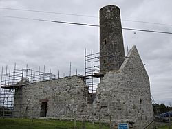
The tall, round tower you see at the site was built later, in the 12th century. The main church building, with its special corner pillars called antae, was built even later, around the 15th or 16th century. Over time, the church was no longer used and slowly fell into ruin.
There's a fun local story that says the round tower was built in just one night by a witch! In 1833, a man named John Windele visited the site and drew pictures of it. More recently, in 2019, some work was done to help preserve the ruins.
What Can You See There Today?
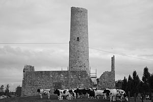
The most striking part of Dísert Óengusa is its round tower. It stands about 20.65 meters (about 68 feet) tall. The tower is about 5.28 meters (about 17 feet) wide. Its entrance, which is in the Romanesque style, is quite high up, about 4.6 meters (about 15 feet) above the ground.
The church building is a simple rectangle. It measures about 15.5 meters (about 51 feet) long and 5 meters (about 16 feet) wide. Even though it's in ruins, you can still imagine what this ancient place was like long ago.
 | Delilah Pierce |
 | Gordon Parks |
 | Augusta Savage |
 | Charles Ethan Porter |


