Eagle Lake (British Columbia) facts for kids
Quick facts for kids Eagle Lake |
|
|---|---|

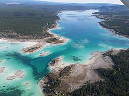
Aerial View of Eagle Lake
|
|
| Location | Chilcotin District, British Columbia |
| Coordinates | 51°54′47″N 124°23′13″W / 51.91306°N 124.38694°W |
| Primary outflows | none |
| Basin countries | Canada |
| Max. length | 10 km (6.2 mi) |
| Max. width | 1.5 km (0.93 mi) |
| Surface area | 11.9 km2 (4.6 sq mi) |
| Average depth | 17.9 m (59 ft) |
| Max. depth | 48 m (157 ft) |
| Water volume | 0.21 km3 (0.050 cu mi) |
| Residence time | A very long time |
| Shore length1 | 29.3 km (18.2 mi) |
| Surface elevation | 1,042 m (3,419 ft) |
| Islands | 5 in 1970 with the number fluctuating up and down as the water level drops. |
| 1 Shore length is not a well-defined measure. | |
Eagle Lake is a special kind of lake in the western Chilcotin District of British Columbia, Canada. It's located southeast of Tatla Lake and west of the city of Williams Lake. This lake is a popular spot in summer because its water is warm and sky-blue. It also has beautiful white sand beaches.
About Eagle Lake
Eagle Lake is known as an "endorheic" lake. This means that water flows into it, but no rivers or streams flow out of it. Because of this, the water level in Eagle Lake has been dropping over time. Since 1970, the lake's water level has gone down by more than 6 meters.
Water Levels and Islands
The dropping water level has changed the lake's shape. What used to be islands in the lake are now connected to the shoreline. Also, new islands have appeared in the western part of the lake as the water has receded. This shows how much the lake has changed over the years.
Clear Water
The water in Eagle Lake is incredibly clear. Scientists measure water clarity using something called a Secchi depth disk. You lower the disk into the water until you can't see it anymore. The depth at which it disappears is the Secchi depth. Eagle Lake has a very high Secchi depth of 13.4 m (44 ft). This might even be the highest in all of British Columbia!
 | Toni Morrison |
 | Barack Obama |
 | Martin Luther King Jr. |
 | Ralph Bunche |


