
EastLink, Melbourne facts for kids
EastLink is a major tollway in Melbourne, Victoria, Australia. A tollway means you need to pay a fee to drive on it. This important road opened on June 28, 2008. It connects the Frankston Freeway to the Eastern Freeway, making travel easier across Melbourne. EastLink also features two cool tunnels: the Mullum Mullum tunnel and the Melba tunnel.


How to Pay for EastLink
To use EastLink, drivers pay a fee called a toll. There are a few ways to do this. You can get an electronic tag, like a Breeze tag, for your car. This tag automatically records your trips and charges your account. If you don't have a tag, you can buy a special pass from a shop or receive a bill in the mail after your trip.
Tom Wills Interchange
One of the biggest intersections on EastLink is called the Tom Wills interchange. It connects EastLink with the Monash Freeway. This interchange is the largest in Victoria. It was named after Tom Wills, a famous person in Australian sports history. The interchange is also close to Waverely Park, which is a well-known sports ground and was once home to the Hawthorn Football Club.
Connecting Melbourne
EastLink is a very long road, about 45 kilometers (28 miles) long. It helps people travel across many different suburbs in Melbourne. It has many exits and entrances that connect to other major roads and local streets. This makes it easier for drivers to get where they need to go quickly. The road passes over or under many other roads and even railway lines, showing how big and complex it is.
Images for kids
-
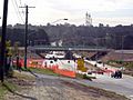
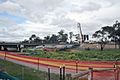
Construction of EastLink over Boronia Road in Wantirna
-
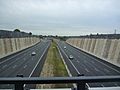
Eastlink in December 2009
-
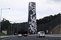
Ringwood portal of the tunnels under the Mullum Mullum Valley
-
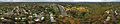
Hillcrest Reserve and the Eastlink Melba Tunnel in January 2020
-
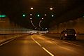
Inside the Melba (westbound) tunnel
-
Constructing the EastLink bridge over Dandenong Creek, in Ringwood/Wantirna


