East Clear Creek facts for kids
Quick facts for kids East Clear Creek |
|
|---|---|

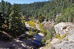
East Clear Creek at Forest Road 95
|
|
| Country | United States |
| State | Arizona |
| Physical characteristics | |
| Main source | 6,800 ft (2,100 m) |
East Clear Creek is a beautiful stream located in the Mogollon Rim area of Arizona. It's a great spot for outdoor adventures. The closest town to this creek is Winslow, which is about 45 miles (72 km) away.
Exploring East Clear Creek
East Clear Creek is known for its scenic beauty and trails. One famous spot is Kinder Crossing. This crossing was named after Runyon C. Kinder, who used to herd sheep in the area back in the 1880s.
The Kinder Crossing Trail is a popular hiking route that follows the creek. Besides Kinder Crossing, you can also find other crossings with trails, such as Horse Crossing, Jones Crossing, and Mack Crossing. These trails offer different ways to explore the creek and its surroundings.
Where to Find East Clear Creek
East Clear Creek starts high up in Coconino County, Arizona. Its source is located at 34°27′55″N 111°20′27″W / 34.46531°N 111.34097°W.
The creek then flows until it joins another stream called Clear Creek (Little Colorado River tributary). This meeting point, or confluence, is also in Coconino County, Arizona, at 34°37′25″N 111°02′22″W / 34.62364°N 111.03958°W.
Fish You Can Find Here
East Clear Creek is a popular spot for fishing. There are about 34 miles (55 km) of the creek where you can fish. Anglers often catch different types of trout here:
 | James Van Der Zee |
 | Alma Thomas |
 | Ellis Wilson |
 | Margaret Taylor-Burroughs |

