East Harriet, Minneapolis facts for kids
Quick facts for kids
East Harriet
East Harriet Farmstead
|
|
|---|---|
|
Neighborhood
|
|

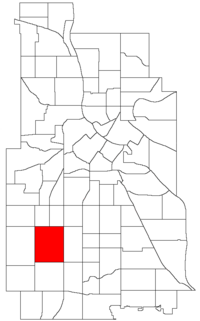
Location of East Harriet within the U.S. city of Minneapolis
|
|
| Country | United States |
| State | Minnesota |
| County | Hennepin |
| City | Minneapolis |
| Community | Southwest |
| City Council Ward | 13 |
| Area | |
| • Total | 1.224 sq mi (3.17 km2) |
| Population
(2020)
|
|
| • Total | 3,654 |
| • Density | 2,985.3/sq mi (1,152.6/km2) |
| Time zone | UTC-6 (CST) |
| • Summer (DST) | UTC-5 (CDT) |
| ZIP code |
55408, 55409
|
| Area code(s) | 612 |
| Historical population | |||
|---|---|---|---|
| Census | Pop. | %± | |
| 1980 | 3,864 | — | |
| 1990 | 3,954 | 2.3% | |
| 2000 | 3,999 | 1.1% | |
| 2010 | 3,604 | −9.9% | |
| 2020 | 3,654 | 1.4% | |
East Harriet is a friendly neighborhood located in the Southwest part of Minneapolis, a big city in Minnesota. It's known for its beautiful surroundings and community feel.
This neighborhood has clear borders. To the north, you'll find West 36th Street. Lyndale Avenue South is on its east side. West 46th Street forms the southern boundary. On the west, East Harriet is next to Lake Harriet, Lakewood Cemetery, and William Berry Parkway.
The home of Theodore Wirth, a famous architect who designed many parks in Minneapolis, is located in the western part of this neighborhood. He helped make Minneapolis parks beautiful.
East Harriet is part of a local government area called Ward 13. This ward is currently represented by Linea Palmisano, who is a member of the Minneapolis City Council. Before 2022, most of the neighborhood was in Ward 10.
Schools in East Harriet
East Harriet is home to several schools that serve students from kindergarten through high school. These schools help young people learn and grow in the community.
Elementary School
- Lyndale Community School (Kindergarten to 5th grade)
- Address: 312 West 34th Street, Minneapolis, MN 55408
- Phone: (612) 668-4000
Middle School
- Ramsey Middle School (6th to 8th grade)
- Address: 1 West 49th Street, Minneapolis, MN 55419
- Phone: (612) 668-0455
High School
- Washburn Senior High School (9th to 12th grade)
- Address: 201 West 49th Street, Minneapolis, MN 55419-5588
- Phone: (612) 668-3400
Local Businesses
East Harriet has many different businesses that serve the people living there. These businesses help the neighborhood thrive and offer various services and products. You can find more information about them through local community guides.
 | Emma Amos |
 | Edward Mitchell Bannister |
 | Larry D. Alexander |
 | Ernie Barnes |

