
East Shreve Run facts for kids
Quick facts for kids East Shreve Run |
|
|---|---|


|
|
| Other name(s) | Tributary to Oil Creek |
| Country | United States |
| State | Pennsylvania |
| County | Crawford Erie |
| Township | Bloomfield |
| Physical characteristics | |
| Main source | divide between East Shreve Run and South Branch French Creek Union Township, Erie County 1,575 ft (480 m) 41°49′00″N 079°50′00″W / 41.81667°N 79.83333°W |
| River mouth | Lake Canadohta Lake Canadohta 1,389 ft (423 m) 41°49′00″N 079°50′00″W / 41.81667°N 79.83333°W{ |
| Length | 3.42 mi (5.50 km) |
| Basin features | |
| Progression | south |
| River system | Allegheny River |
| Basin size | 3.03 square miles (7.8 km2) |
| Tributaries |
|
| Bridges | State Game Land Road, Mt Pleasant Road |
East Shreve Run is a small stream, about 3.42 miles (5.50 km) long. It flows into Lake Canadohta, which is part of Oil Creek, in Crawford County, Pennsylvania. The land around the stream is mostly covered by forests and farms. About 43% of the area is forest, and 50% is used for farming.
Where Does East Shreve Run Flow?
East Shreve Run starts in Union Township, Pennsylvania. This area is near the divide between East Shreve Run and another stream called South Branch French Creek. From its source, the stream flows south. It travels through a flat, open area known as the Erie Drift Plain. Finally, it reaches Lake Canadohta, which is part of Oil Creek, also in Pennsylvania.
What is the East Shreve Run Watershed?
A watershed is an area of land where all the water drains into a single stream or river. The East Shreve Run watershed covers about 3.03 square miles (7.85 square kilometers). This area gets a good amount of rain each year, about 46.4 inches (118 cm). A large part of this watershed, about 45%, is covered by forests.
Images for kids
-
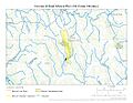
Map showing the path of East Shreve Run.
-
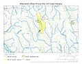
A map of the East Shreve Run watershed.
.jpg)
.jpg)
