Edinburgh Island facts for kids

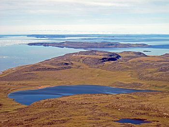
Looking south on Edinburgh Island
|
|
| Geography | |
|---|---|
| Location | Coronation Gulf |
| Coordinates | 68°31′N 110°51′W / 68.517°N 110.850°W |
| Archipelago | Canadian Arctic Archipelago |
| Administration | |
| Territory | Nunavut |
| Region | Kitikmeot |
| Demographics | |
| Population | Uninhabited |
Edinburgh Island is a small, uninhabited island in Canada's Arctic region. It is located in the Coronation Gulf, a large body of water in northern Canada. The island sits south of the much larger Victoria Island.
Edinburgh Island is part of the Kitikmeot Region in Nunavut, a territory in northern Canada. The island is about 103 meters (338 feet) above sea level. This means it rises quite a bit from the surrounding water.
Exploring Edinburgh Island
Edinburgh Island is found in the Coronation Gulf, which is part of the vast Canadian Arctic Archipelago. This archipelago is a group of many islands in the Arctic Ocean. The area is known for its cold climate and beautiful, rugged landscapes.
Neighbors in the Arctic
Edinburgh Island has several other islands nearby. These islands are also part of the Canadian Arctic. Some of its neighbors include:
These islands are all part of the amazing and remote Arctic environment.
A Watchful Eye: Edinburgh Island's History
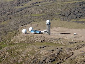
Even though no one lives on Edinburgh Island permanently, it has played an important role in North American defense. The island was once a site for the Distant Early Warning Line, often called the DEW Line.
The DEW Line was a chain of radar stations built during the Cold War. Their purpose was to detect any incoming aircraft or missiles from the north. This system helped protect Canada and the United States.
Today, Edinburgh Island is part of the North Warning System. This modern system continues to monitor the skies over North America. It helps to ensure the safety of the continent. The specific site on Edinburgh Island is known as PIN-DA.
 | Toni Morrison |
 | Barack Obama |
 | Martin Luther King Jr. |
 | Ralph Bunche |


